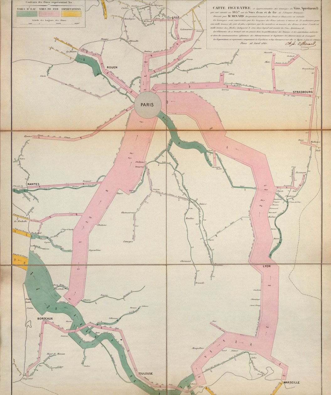
Map Representing the Approximate Tonnage of Wines and Spirits in Circulation in France by Water and by Railway by Charles Joseph Minard

Map Representing the Approximate Tonnage of Wines and Spirits in Circulation in France by Water and by Railway

(Map representing the approximate tonnage of wines and spirits in circulation in France in 1857 by water and by railway, 1860 )


Charles Joseph Minard

€ 0.00
Enthält ??% MwSt.
   Add to cart
   Configure art print
1860  ·  colour lithograph  ·  Picture ID: 184096

Nonclassified artists  ·  Cartography

Map Representing the Approximate Tonnage of Wines and Spirits in Circulation in France by Water and by Railway by Charles Joseph Minard. Available as an art print on canvas, photo paper, watercolor board, uncoated paper or Japanese paper.
wine · liquor · circulation · canals · transport · commerce · trade · transportation · rail · Archives de l'Ecole Nationale des Ponts et Chaussees, Paris / Bridgeman Images
zu Favoriten hinzufügen   Add to favorites    Select wall color    View painting in a room AR/3D   View in 3D / AR
0 Reviews

Configure art print

Picture Frame

Medium & Stretcher

Glass & Passepartout

Miscellaneous & Extras

 Save / compare configuration
Preview Icon

Summary

Gemälde
Veredelung
Keilrahmen
Museumslizenz

€ 109.31
(inkl. 20% MwSt)
   Add to cart

Bildschärfe: PERFEKT

Should you desire adjustments to brightness and color, or a custom crop of the motif, we are happy to make these changes at no additional cost to you. Please do not hesitate to contact us.

Similar artworks selected for you

D2, Gomersall, Healey, Heckmondwike & Part of Dewsbury Map of the Township of Oxford, Boroughs of Frankford & Bridesburg with Parts of Bristol, N. Liberties and Cheltenham Townships, 1849 C1 South Bradford, Bolling Hall, Bowling & North Brierley Plan of Bridgetown, Barbadoes, showing the Part destroyed by the Recent Fire B1, Idle, Shipley, Esholt Hall, Eccleshill and Part of Bradford Topographical Sketch of the Environs of Washington, D.C. Stephenson Map of the Paris to St. Germain Railway, by A.M. Perrot Map from the National Library D5, Altofts, Normanton, Stanley & Warmfield C5, Temple Newsam, Colton, Swillington, Woodlesford, Oulton & Methley C2, Pudsey, Tong, Drighlington & Birstall Course of the Scheldt from Fort Bath to Antwerp, 1832 England, East coast, entrance to the River Humber surveyed by Captain G.E. Richards HM surveying ship Plan of the Osaka First or Winter Campaign, 1614, 1903 A Map showing Middle Atlantic Colonies: Army Positions A Topographical Sketch of New York The City of London in the Time of the Saxon Dynasty, about the Year One Thousand, pub. by William Darton, London Vicksburg, Mississippi, and Its Defences Plan of Choul and Surat River The Battle of Waterloo, 1815-1816 Vicinity of Harpers Ferry C4, South Leeds, Hunslet, Thorp, Middleton, Rothwell Haigh & Carlton Map of the Seat of War in Virginia Map of Vicksburg A Plan Showing the Battle of Albuera B2, Calverly, Rawdon, Bramley, Rodley, Horsforth, Farsley & Stanningley A New and Correct Map of Hackney Marsh, 1745 Talke - Clough Hall
Show more similar artworks

Other motives from the category Cartography

City Map of Ancient Jerusalem, from Map of Peru, from Map of Lubeck and Hamburg, from Map of the Southern Hemisphere, from Map of Metz from Map of Lucca and Pisa, Tuscany, Italy The Triumph of the French Armies, Napoleon and His Generals Holding Maps of Their Victories at the Time of the Peace of Loeben, 18th April 1797 Map of Palestine, Palestina Antiqua, from Map of Africa, Published in 1700, Paris Map of Modern London and Its Environs, 1845 Map of the Old and New Worlds, c.1500 Map of Siberia Showing the Immense Natural Resources of the Area and Depicting a Sea Route Which Would Open Up Trade, 1933 Map of Spain and Portugal showing the political divisions in the country at the death of Alfonso III, King of Leon, from Septentrionalium terrarum descriptio, map of the Arctic, 1595 Map showing the localities of the Indian tribes of the US in 1833, illustration from
View More from "Cartography"

Excerpt from our top sellers

Resting, 1930 In Bed: The Kiss The Garden of the Artist in Wannsee, 1918 Flower Still Life on a Marble Ledge Circles in a Circle The Tower of Babel (Vienna) The Buddha Roses Stein on the Danube (District of Krems) Upwards Lady Godiva Four Foxes The Red Tree Woman in Tehuantepec, Mexico Merry Christmas
Show More Artworks


What our customers think about us


Frequently Asked Questions about Meisterdrucke


Personalizing your art print at Meisterdrucke is a simple and intuitive process that allows you to design an artwork exactly to your specifications: Choose a frame, determine the image size, decide on a printing medium, and add suitable glazing or a stretcher frame. We also offer customization options such as mats, fillets, and spacers. Our customer service is available to help you design your perfect artwork.

At Meisterdrucke, you have the fascinating option to visualize the artwork you configured directly in your own space. For a tailored preview, simply upload a photo of your room and let the artwork appear on it. If you visit us via a mobile device, be it a phone or tablet, our augmented reality feature brings the image to life and seamlessly projects it into your space. An experience that uniquely combines art and technology.

Choosing the medium is often a matter of personal taste. To give you a clearer idea, we have provided some images for each medium. For a holistic experience, we also offer you a sample set of all paper variants so you can make a decision not just visually but also haptically. You can take advantage of the sample set free of charge – only the shipping costs will apply. You can order the sample set directly.

Do not worry. At Meisterdrucke, we do not proceed mechanically. We manually review each order. If there are any inconsistencies or peculiarities in the configuration, we will immediately contact you. Of course, our courteous and patient support is always at your side to assist you with the configuration. Together with you, we adjust your image by phone or email so that the final result exactly meets your expectations.


Do you have any questions?

Are you interested in an art print from our manufactory but still unsure? Do you need advice on choosing the medium or help with the order?

Our experts are happy to assist you.

+43 4257 29415
support@meisterdrucke.com
Mo-Do: 7:00 - 16:00 | Fr: 7:00 - 13:00

Do you have any questions?

Are you interested in an art print from our manufactory but still unsure? Do you need advice on choosing the medium or help with the order?

Our experts are happy to assist you.

+43 4257 29415
support@meisterdrucke.com
Mo-Do: 7:00 - 16:00 | Fr: 7:00 - 13:00


Meisterdrucke

   Kärntner Strasse 46
        9586 Finkenstein am Faaker See
        Austria
        +43 4257 29415
        support@meisterdrucke.com
Other languages

                   
Erfahrungen & Bewertungen zu Meisterdrucke
Partner Logos

Kaiser Franz Joseph

Meisterdrucke
Kärntner Strasse 46
9586 Finkenstein am Faaker See · Austria
+43 4257 29415 · office@meisterdrucke.com
Partner Logos


(c) 2025 meisterdrucke.us