Search by artist, work title or style – e.g. Monet, Starry Night, Impressionism, Hokusai wave, nude. Describe the scene – e.g. green meadow, abstract with lots of red, dark oil painting, standing nude next to a tree.

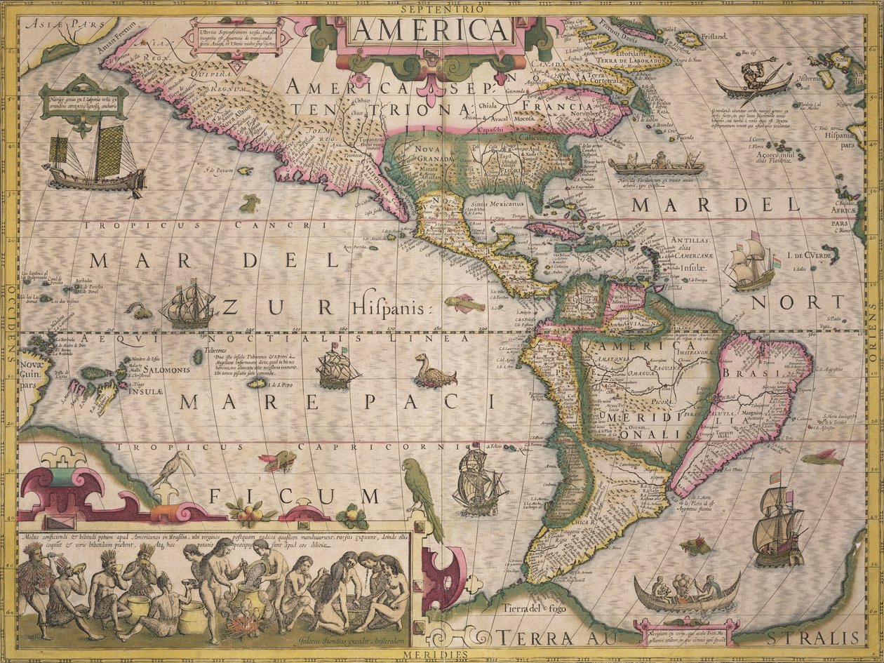
Map of America, from the Mercator Atlas, published by Jodocus Hondius, Amsterdam, 1606 by Dutch School

Map of America, from the Mercator Atlas, published by Jodocus Hondius, Amsterdam, 1606

(Map of America, from the Mercator Atlas, pub. by Jodocus Hondius (1563-1612), Amsterdam, 1606 )


Dutch School

€ 117.86
Enthält 0% MwSt.
   Configure art print
1606  ·  coloured engraving  ·  Picture ID: 416674

Cultural Circles  ·  Cartography

Map of America, from the Mercator Atlas, published by Jodocus Hondius, Amsterdam, 1606 by Dutch School. Available as an art print on canvas, photo paper, watercolor board, uncoated paper or Japanese paper.
ship · boat · sea monster · natives · native american · americans · making liquor · canoe · parrot · south · Private Collection / Bridgeman Images
AR/3D   View in 3D / AR zu Favoriten hinzufügen   Add to favorites    Select wall color    View painting in a room
0 Reviews

Configure art print

Picture Frame

Medium & Stretcher

Glass & Passepartout

Miscellaneous & Extras

 Save / compare configuration
Preview Icon

Summary

Gemälde
Veredelung
Keilrahmen
Museumslizenz

€ 117.86
(inkl. 20% MwSt)
   Add to cart

Bildschärfe: PERFEKT

Should you desire adjustments to brightness and color, or a custom crop of the motif, we are happy to make these changes at no additional cost to you. Please do not hesitate to contact us.

Similar artworks selected for you

New and Accurate Map of America Ortelius America, Plate 84, from Map of the Western Hemisphere in 1626 A Map of America Map of the Americas, 1631 Map of The Americas or the New World, Newly Described Plate depicting the map of Southern America The Americas Sheet from Blaeu Geographic map of America. In Le theatre du monde ou le nouvel atlas Amsterdam produced by Willem Janszoon Blaeu (1571-1638) Chart of the Americas, c.1671 Map of America Map of South America The Pacific Ocean America The Caribbean Sea: Gulf of Mexico and Caribbean Sea from the Atlas of Wilhelm Blaeu Novissima et Accuratissima Totius Americae Descriptio per N. Visscher, 1648 Map of America - Corrected and Enlarged The Visscher Map of the New World Map of Americas and Pacific, from Novissima et Totius Americae Accurate Descriptio Map of the Americas The Caribbean Sea: The Bermuda Triangle between the Bermuda Archipelago, Miami, and Puerto Rico. According to Wilhelm Blaeu America America, or the New World: From the Theatrum Orbis Terrarum by Abraham Ortelius, 1570 Map of the Pacific, China and America, 1589 Map of Central America Maris Pacifici
Show more similar artworks

Other art prints by Dutch School

Plaque with a Chinoiserie Landscape and Gilt Details, c.1680 Map of New Holland, Now Australia, and of New Zealand Martin Luther preaching (detail) A Planisphere with Signs of Zodiac Terrarum Orbis Tabula (after G. a Schagen, c.1689) A Dodo China Miracle of Our Lady of Nazare, Our Lady of Nazare Church, Portugal Interior of a Dutch House, 1st Half of 17th Century The Money Lender Frontispiece of Dutch Chart Atlas showing a group of cartographers and instruments, c.1710 Map of the Cape of Good Hope. Table Bay, South Africa Compass Rose, from a Blaue Atlas, published in Amsterdam Map of the Magellan Straits, Patagonia Title Page of Principia Philosophiae by Rene Descartes
Discover more works by Dutch School

Other motives from the category Cartography

Map of Yorkshire, engraved by William Web, published 1645 Map Charting the Orbit of the Moon around the Earth, from Map Showing the New Frontier Line Between Russia and Turkey as Settled by the Treaty, 30 March 1856 Map of Kent Map of Florence, 1730 Map of the city of Siam, capital of the kingdom of that name after a survey done by a French engineer in 1687, published in the 1751 edition of Histoire Generale des Voyages by Antoine Prevost Map Showing the route of the Armada fleet, engraved by Augustine Ryther Map of Christian Constellations, from Map Depicting the Destruction of the Spanish Colony of St. Augustine in Florida on 7th July 1586 by the English Fleet Commanded by Sir Francis Drake Map of Arras, from Map of London in the Time of the Romans The Holy Land, from an Atlas of the World in 33 Maps, Venice Part of the Tabula Peutingeriana, an illustrated itinerarium of the road network in the Roman Empire. Detail of Italy from the Peutinger map copy Map of Palma, from Map of France, Spain and North-West Africa, from the
View More from "Cartography"

Excerpt from our top sellers

The Dreamer The Three Sisters on the Beach La Primavera The Girl with a Pearl Earring Composition VIII Hands of the Puppeteer Seated Woman with Raised Knee Elizabeth of Bavaria (1837-98), Empress of Austria, Wife of Emperor Franz Joseph of Austria (1830-1916) Standing Woman in Red Cupid as Victor Heath Princess Whaling in the Polar Sea Composition No. VII, 1913 Pont Neuf, Paris Lake Thun with Niesen
Show More Artworks


What our customers think about us


Frequently Asked Questions about Meisterdrucke


Personalizing your art print at Meisterdrucke is a simple and intuitive process that allows you to design an artwork exactly to your specifications: Choose a frame, determine the image size, decide on a printing medium, and add suitable glazing or a stretcher frame. We also offer customization options such as mats, fillets, and spacers. Our customer service is available to help you design your perfect artwork.

At Meisterdrucke, you have the fascinating option to visualize the artwork you configured directly in your own space. For a tailored preview, simply upload a photo of your room and let the artwork appear on it. If you visit us via a mobile device, be it a phone or tablet, our augmented reality feature brings the image to life and seamlessly projects it into your space. An experience that uniquely combines art and technology.

Choosing the medium is often a matter of personal taste. To give you a clearer idea, we have provided some images for each medium. For a holistic experience, we also offer you a sample set of all paper variants so you can make a decision not just visually but also haptically. You can take advantage of the sample set free of charge – only the shipping costs will apply. You can order the sample set directly.

Do not worry. At Meisterdrucke, we do not proceed mechanically. We manually review each order. If there are any inconsistencies or peculiarities in the configuration, we will immediately contact you. Of course, our courteous and patient support is always at your side to assist you with the configuration. Together with you, we adjust your image by phone or email so that the final result exactly meets your expectations.


Do you have any questions?

Are you interested in an art print from our manufactory but still unsure? Do you need advice on choosing the medium or help with the order?

Our experts are happy to assist you.

+43 4257 29415
support@meisterdrucke.com
Mo-Do: 7:00 - 16:00 | Fr: 7:00 - 13:00

Do you have any questions?

Are you interested in an art print from our manufactory but still unsure? Do you need advice on choosing the medium or help with the order?

Our experts are happy to assist you.

+43 4257 29415
support@meisterdrucke.com
Mo-Do: 7:00 - 16:00 | Fr: 7:00 - 13:00


Meisterdrucke

   Kärntner Strasse 46
        9586 Finkenstein am Faaker See
        Austria
        +43 4257 29415
        support@meisterdrucke.com
Other languages

                   
Erfahrungen & Bewertungen zu Meisterdrucke
Post.at DHL Express Quehenberger Cargoboard
Kaiser Franz Joseph

Meisterdrucke
Kärntner Strasse 46
9586 Finkenstein am Faaker See · Austria
+43 4257 29415 · office@meisterdrucke.com
Post.at DHL Express Quehenberger Cargoboard


Meisterdrucke 2746 Bewertungen auf ProvenExpert.com

(c) 2025 meisterdrucke.us