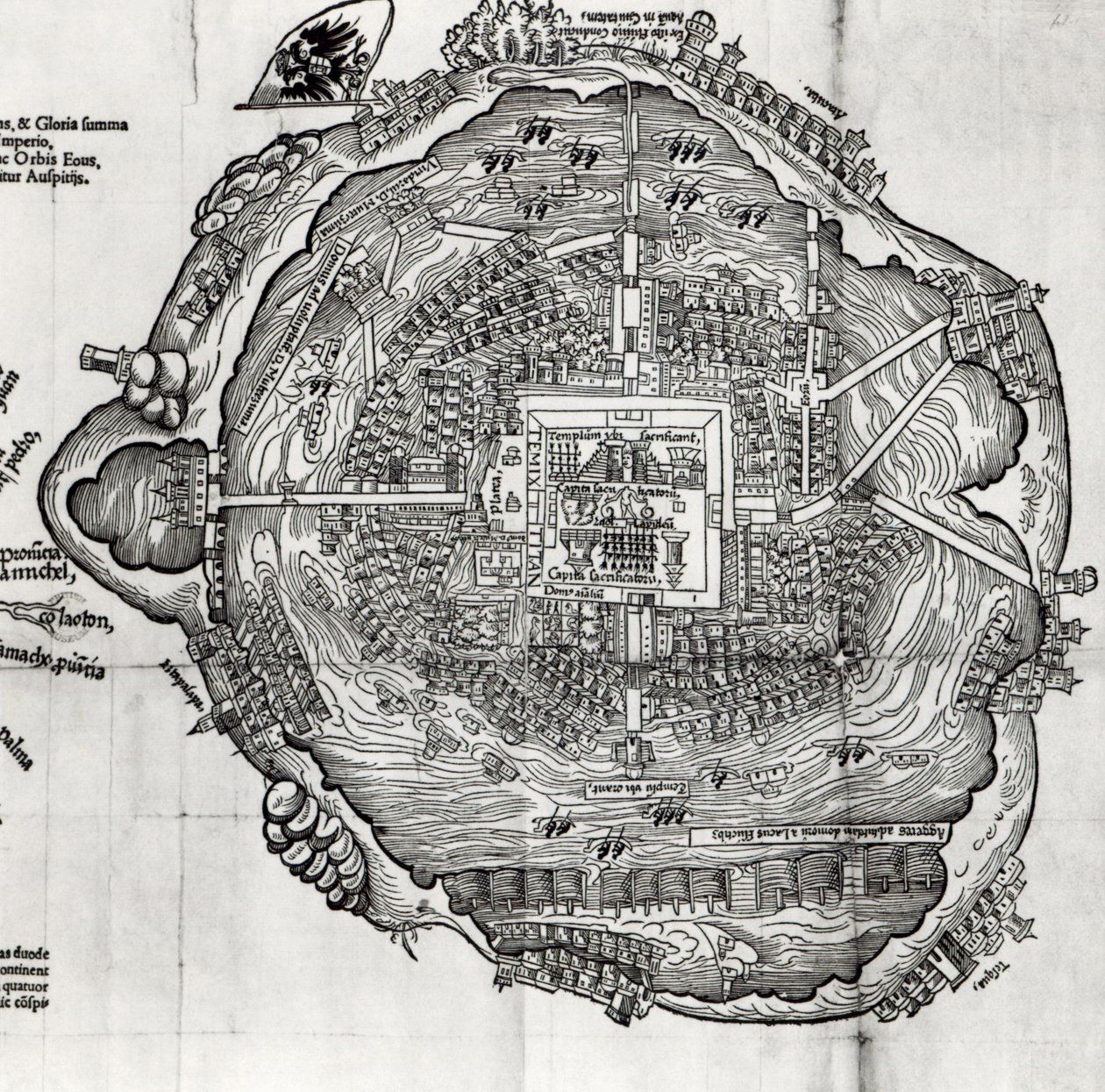
Map of Tenochtitlan from

Map of Tenochtitlan from 'Praeclara Ferdinandi Cortesii de Nova Maris Oceani Hispania Narrati'

(Map of Tenochtitlan from 'Praeclara Ferdinandi Cortesii de Nova Maris Oceani Hispania Narrati' )


German School

€ 96.73
Enthält 0% MwSt.
   Configure art print
1524  ·  Holzschnitt  ·  Picture ID: 88856

Cultural Circles  ·  Cartography

Map of Tenochtitlan from 'Praeclara Ferdinandi Cortesii de Nova Maris Oceani Hispania Narrati' by German School. Available as an art print on canvas, photo paper, watercolor board, uncoated paper or Japanese paper.
floating city · aztec · empire · spain · lake · texcoco · pyramid · temple · capital · island · cartography · exploration · Private Collection / Bridgeman Images
Other color variations of this picture  
zu Favoriten hinzufügen   Add to favorites    Select wall color    View painting in a room AR/3D   View in 3D / AR
0 Reviews

Configure art print

Picture Frame

Medium & Stretcher

Glass & Passepartout

Miscellaneous & Extras

 Save / compare configuration
Preview Icon

Summary

Gemälde
Veredelung
Keilrahmen
Museumslizenz

€ 96.73
(inkl. 20% MwSt)
   Add to cart

Bildschärfe: PERFEKT

Should you desire adjustments to brightness and color, or a custom crop of the motif, we are happy to make these changes at no additional cost to you. Please do not hesitate to contact us.

Similar artworks selected for you

Plan of Mexico, in Hernando Cortés, La Preclara Narratione di Ferdinando Cortese della Nuova Hispagna, Venice Map of Tenochtitlan and the Gulf of Mexico, from Praeclara Ferdinadi Cortesii de Nova maris Oceani Hyspania Narratio by Hernando Cortes (1485-1547) 1524 Map of Jerusalem, 1661 Map of Jerusalem and the Surrounding Area, from The Scenography of a Town and Castle with All the Usual Outworks and the Manner of Carrying Out a Siege, from Map of Palmanova, engraving from Civitates Orbis Terrarum Map of Palmanova, 1726 Plan of Lisle Comet of 66 AD Halley over Jerusalem Map of Palmanova, from Les Villes de Venetie, 1704, published by Rutgert Alberts in the Hague Map of Jerusalem and the Surrounding Area Map of the Roman Forum Map Illustrating La Rochelle Occupied by the Huguenots Palmanova, Udine Province, Italy (engraving) Catania with Mount Etna, Italy - in Capture of Calais by Archduke Albert, 1596 Canterbury, 1588 Plan of the Port of Ostia Antica, Engraved by the Artist Great city of Milan City Map of Moscow in the 17th Century. Panoramic view of Canterbury in the sixteenth century, illustration from The Church of England: A History for the People by H.D.M. Spence-Jones City of Quinsai, Engraving from La Cosmographie Universelle by Andre Thevet Map of Jerusalem and the Surrounding Area, from Map of Antwerp Plan and fortifications of Lille around 1670, from Map of Poltava in the Early 18th Century Siege of Algiers by Charles V in 1541 The siege of the city of Barcelona by troops of King Philip IV during the Reapers
Show more similar artworks

Other art prints by German School

Poster advertising the Hamburg-Amerika Line Wyk auf Föhr, Poster Advertising the Wyk Steam Shipping Company, 1897 Poster advertising the Hamburg-Amerika Line Woman Bathing Poster for the Industrial Exhibition in Berlin, Germany, 1896 St. Brendan and a Siren, from the German Translation of Navigatio Sancti Brendani Abbatis Portrait of Kaiser Wilhelm II (1859-1941) The Whore of Babylon, from the Luther Bible King Frederick William I on Horseback with Potsdam in the background, c.1735 Fantastic Depiction of the Solar System Arthur Schopenhauer Prince Otto of Bismarck-Schoenhausen, 8th February 1891 Poster Advertising the German East Africa Line, 1890 Sylt North Sea Baths, Poster Advertising the Sylt Steamship Company, 1893 Poster advertising Hamburg-Amerika Linie routes to the West Indies and Central America
Discover more works by German School

Other motives from the category Cartography

Renaissance map of Europe, Jacopo Russo (after) 1528 Map of Brobdingnag, illustration from the first edition of A New Map of the Kingdom of England and the Principality of Wales, 1669 A New and Accurate Map of the World Map of the Ottoman Empire, Kingdom of Greece, and the Russian Provinces on the Black Sea Map of The Moluccan Island, Engraved by Jodocus Hondius, 1630 A map showing the journey of the Israelites out of Egypt and into Canaan, facsimile of an image from the Geneva Bible of 1560 Map of the Wards of Coleman Street and Bassishaw, London Geological Map of the Kutch Region of India, Geological Survey of India 1868-69 Map of the Countries of the Persian Gulf, from the Map of the Strait of Magellan, plate from Oliver van Noort Map of Nottinghamshire Map of Africa Map of the Magellan Straits, Patagonia Part of South Australia, from a Series of World Maps published by John Tallis und Co, New York and London
View More from "Cartography"

Excerpt from our top sellers

Sunset Over the Lake Women of Tahiti, On the Beach, 1891 Pandemonium Adele Bloch-Bauer Portrait of the philosopher and esotericist Rudolf Steiner Reduced Weight The Temptation of St. Anthony, right hand panel, detail of a couple riding a fish The Blue Rigi: Lake of Lucerne - Sunrise Dream of Arcadia Praying Hands The Dragon among Clouds Nuda Veritas Moonrise by the Sea King of the Forest, 1878 The Great Wave off Kanagawa
Show More Artworks


What our customers think about us


Frequently Asked Questions about Meisterdrucke


Personalizing your art print at Meisterdrucke is a simple and intuitive process that allows you to design an artwork exactly to your specifications: Choose a frame, determine the image size, decide on a printing medium, and add suitable glazing or a stretcher frame. We also offer customization options such as mats, fillets, and spacers. Our customer service is available to help you design your perfect artwork.

At Meisterdrucke, you have the fascinating option to visualize the artwork you configured directly in your own space. For a tailored preview, simply upload a photo of your room and let the artwork appear on it. If you visit us via a mobile device, be it a phone or tablet, our augmented reality feature brings the image to life and seamlessly projects it into your space. An experience that uniquely combines art and technology.

Choosing the medium is often a matter of personal taste. To give you a clearer idea, we have provided some images for each medium. For a holistic experience, we also offer you a sample set of all paper variants so you can make a decision not just visually but also haptically. You can take advantage of the sample set free of charge – only the shipping costs will apply. You can order the sample set directly.

Do not worry. At Meisterdrucke, we do not proceed mechanically. We manually review each order. If there are any inconsistencies or peculiarities in the configuration, we will immediately contact you. Of course, our courteous and patient support is always at your side to assist you with the configuration. Together with you, we adjust your image by phone or email so that the final result exactly meets your expectations.


Do you have any questions?

Are you interested in an art print from our manufactory but still unsure? Do you need advice on choosing the medium or help with the order?

Our experts are happy to assist you.

+43 4257 29415
support@meisterdrucke.com
Mo-Do: 7:00 - 16:00 | Fr: 7:00 - 13:00

Do you have any questions?

Are you interested in an art print from our manufactory but still unsure? Do you need advice on choosing the medium or help with the order?

Our experts are happy to assist you.

+43 4257 29415
support@meisterdrucke.com
Mo-Do: 7:00 - 16:00 | Fr: 7:00 - 13:00


Meisterdrucke

   Kärntner Strasse 46
        9586 Finkenstein am Faaker See
        Austria
        +43 4257 29415
        support@meisterdrucke.com
Other languages

                   
Erfahrungen & Bewertungen zu Meisterdrucke
Partner Logos

Kaiser Franz Joseph

Meisterdrucke
Kärntner Strasse 46
9586 Finkenstein am Faaker See · Austria
+43 4257 29415 · office@meisterdrucke.com
Partner Logos


(c) 2025 meisterdrucke.us