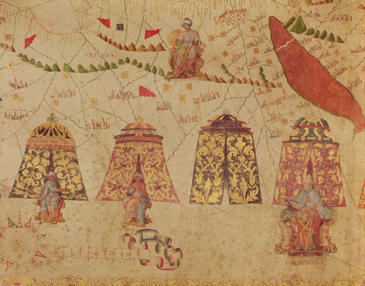
East Africa and the Red Sea with Prester John and the Legendary Kings of Africa, detail from a map of the Mediterranean Sea by Vesconte de Maggiolo, 1563 by Italian School

East Africa and the Red Sea with Prester John and the Legendary Kings of Africa, detail from a map of the Mediterranean Sea by Vesconte de Maggiolo, 1563

(East Africa and the Red Sea with Prester John and the Legendary Kings of Africa, detail from a map of the Mediterranean Sea by Vesconte de Maggiolo, 1563 )


Italian School

€ 114.31
Enthält 0% MwSt.
   Configure art print
1563  ·  vellum  ·  Picture ID: 420237

Cultural Circles  ·  Cartography

East Africa and the Red Sea with Prester John and the Legendary Kings of Africa, detail from a map of the Mediterranean Sea by Vesconte de Maggiolo, 1563 by Italian School. Available as an art print on canvas, photo paper, watercolor board, uncoated paper or Japanese paper.
african · tent · king · pretre jean · mediterranean sea · legendary kings · ethiopia · abyssinia · tents · Bibliotheque Nationale de Cartes et Plans, Paris, France / Bridgeman Images
zu Favoriten hinzufügen   Add to favorites    Select wall color    View painting in a room AR/3D   View in 3D / AR
0 Reviews

Configure art print

Picture Frame

Medium & Stretcher

Glass & Passepartout

Miscellaneous & Extras

 Save / compare configuration
Preview Icon

Summary

Gemälde
Veredelung
Keilrahmen
Museumslizenz

€ 114.31
(inkl. 20% MwSt)
   Add to cart

Bildschärfe: PERFEKT

Should you desire adjustments to brightness and color, or a custom crop of the motif, we are happy to make these changes at no additional cost to you. Please do not hesitate to contact us.

Similar artworks selected for you

Detail from a Catalan World Map Detail of a map depicting Sultan Suleyman I the Magnificent Geographic Map: China, Ganges Valley, Sumatra, Ceylon Renaissance map of Europe, Jacopo Russo (after) 1528 The Detroit of Gibraltar and North Africa, Detail of the Catalan Atlas by Abraham C The king of the Tartars A Caravan Stop, from Geography: detail of a navigation map of Luis Lazare representing the islands of the Tristan da Cunha archipelago and the caravel of the explorer of the same name, off the coast of South Africa Henry IV cuts the family tree Detail from the Catalan Atlas, Sheet 6, Showing the Western Sahara and Mansa Musa Mediterranean, Black Sea and the North East Atlantic An Arab Trader on a Camel (detail) Rustam Discovers the Girl Who Has Betrayed His Love to Mihr Afruz, from the A Nautical Map, detail of the Gran Turco, 1564 Marine Map of the Mediterranean Sea and the Black Sea Map of China (Cathay), with descriptions of small scenes, delimitation of the kingdoms with its sovereign represented each time Edward of York, together with the Earls of Salisbury and Warwick set sail for Calais, following the Battle of Ludford Bridge. King Henry VI looks on in triumph, illustration from Marine Map of the Mediterranean Sea and the Black Sea North Africa, from a nautical atlas, 1520 (detail) Egypt and the Red Sea (detail) from a Renaissance map of Europe, 1528 The Cities of Marseille and Genoa with their ports, from a nautical atlas, 1651 (detail) Detail of a Catalan nautical chart (portulan) representing Asia of the 13th century The North Coast of Africa, from a nautical atlas, 1651 (detail) Detail from the Catalan Atlas (detail) The Red Sea (detail) Map of Florida, Canada and Labrador (from Marco Polo Renaissance map of Europe, Jacopo Russo (after) 1528 Catalan Atlas, Sheet 12, 1375
Show more similar artworks

Other art prints by Italian School

Fra Mauro map The Pasta Eater Bishop Gargallo Otello: Poster for the First Performance of Verdi Battle of Dogali: Italy in Eritrea in February 1887 Portrait of Petrarch (Francesco Petrarca) (1304-74) Portrait of Italian composer Giuseppe Torelli Nude man seen from the rear, late 17th century The Great Chain of Being from Facsimile of the School of Salerno, from the Canon of Medicine by Avicenna A Sea Serpent, from The Legend of Theseus (detail) Portrait of St Charles Borromeo, Italian Archbishop and Cardinal, Church of San Carlo, Arona, Piedmont, Italy Federico Caprilli jumping a chair General view of the Battle of Szigetvar, 1566
Discover more works by Italian School

Other motives from the category Cartography

Map of South America, published in 1700, Paris Map of Australia, from Map of Map of Corsica Map and Plan of Saint-Malo, from the Map of the Turkish Empire, from the Mercator Atlas pub. by Jodocus Hondius Amsterdam, 1606 Map of the Holy Land in Old Testament Times by Mons l Map Showing the Geography of the Hebrews and Exhibiting the Dispersion of the Descendants of Noah Street map of London around Guildhall, c.1795 Map of the Battle of Trafalgar, published by William Blackwood and Sons, Edinburgh and London Map of India, published under the direction of Colonel H.R. Thuillier, R.E., Surveyor General of India, 1877 President Paul Kruger, General Piet Joubert and a Map of the Transvaal and Orange Free State Map of Europe after the Peace of Tilsit in 1807, from
View More from "Cartography"

Excerpt from our top sellers

Blue Picture Beaulieu: The Bay of Fourmis The Origin of the World Lensing Galaxy Cluster (Webb Jockey on a Galloping Horse Red Tree Chichester Canal, c.1829 The Golden Fish Hypnosis Church in Cassone A Stroll on the Beach The Sun Bathers Map of the Battle of Trafalgar, published by William Blackwood and Sons, Edinburgh and London Hip Hip Hurrah! Artists Little Owl
Show More Artworks


What our customers think about us


Frequently Asked Questions about Meisterdrucke


Personalizing your art print at Meisterdrucke is a simple and intuitive process that allows you to design an artwork exactly to your specifications: Choose a frame, determine the image size, decide on a printing medium, and add suitable glazing or a stretcher frame. We also offer customization options such as mats, fillets, and spacers. Our customer service is available to help you design your perfect artwork.

At Meisterdrucke, you have the fascinating option to visualize the artwork you configured directly in your own space. For a tailored preview, simply upload a photo of your room and let the artwork appear on it. If you visit us via a mobile device, be it a phone or tablet, our augmented reality feature brings the image to life and seamlessly projects it into your space. An experience that uniquely combines art and technology.

Choosing the medium is often a matter of personal taste. To give you a clearer idea, we have provided some images for each medium. For a holistic experience, we also offer you a sample set of all paper variants so you can make a decision not just visually but also haptically. You can take advantage of the sample set free of charge – only the shipping costs will apply. You can order the sample set directly.

Do not worry. At Meisterdrucke, we do not proceed mechanically. We manually review each order. If there are any inconsistencies or peculiarities in the configuration, we will immediately contact you. Of course, our courteous and patient support is always at your side to assist you with the configuration. Together with you, we adjust your image by phone or email so that the final result exactly meets your expectations.


Do you have any questions?

Are you interested in an art print from our manufactory but still unsure? Do you need advice on choosing the medium or help with the order?

Our experts are happy to assist you.

+43 4257 29415
support@meisterdrucke.com
Mo-Do: 7:00 - 16:00 | Fr: 7:00 - 13:00

Do you have any questions?

Are you interested in an art print from our manufactory but still unsure? Do you need advice on choosing the medium or help with the order?

Our experts are happy to assist you.

+43 4257 29415
support@meisterdrucke.com
Mo-Do: 7:00 - 16:00 | Fr: 7:00 - 13:00


Meisterdrucke

   Kärntner Strasse 46
        9586 Finkenstein am Faaker See
        Austria
        +43 4257 29415
        support@meisterdrucke.com
Other languages

                   
Erfahrungen & Bewertungen zu Meisterdrucke
Partner Logos

Kaiser Franz Joseph

Meisterdrucke
Kärntner Strasse 46
9586 Finkenstein am Faaker See · Austria
+43 4257 29415 · office@meisterdrucke.com
Partner Logos


(c) 2025 meisterdrucke.us