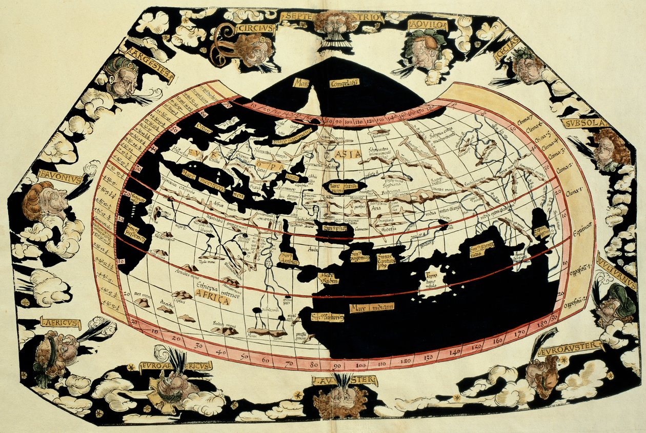
Map of the world, based on descriptions and co-ordinates given in

Map of the world, based on descriptions and co-ordinates given in 'Geographia', by Ptolemy

(Map of the world, based on descriptions and co-ordinates given in 'Geographia', by Ptolemy (Claudius Ptolemaeus of Alexandria) (c.90-168 AD))


Unbekannt Unbekannt

€ 0.00
Enthält ??% MwSt.
   Add to cart
   Configure art print
Undated  ·  Picture ID: 65091

Nonclassified artists  ·  Cartography

Map of the world, based on descriptions and co-ordinates given in 'Geographia', by Ptolemy by Unbekannt Unbekannt. Available as an art print on canvas, photo paper, watercolor board, uncoated paper or Japanese paper.
c02nd · chart · early cartography · geographer · cartographer · O'Shea Gallery, London, UK / Bridgeman Images
Other color variations of this picture  
zu Favoriten hinzufügen   Add to favorites    Select wall color    View painting in a room AR/3D   View in 3D / AR

Note: Only reviews with comments are displayed. Reviews can be submitted directly after purchase in your customer account.

Configure art print

Picture Frame

Medium & Stretcher

Glass & Passepartout

Miscellaneous & Extras

 Save / compare configuration
Preview Icon

Summary

Gemälde
Veredelung
Keilrahmen
Museumslizenz

€ 126.18
(inkl. 20% MwSt)
   Add to cart

Bildschärfe: PERFEKT

Should you desire adjustments to brightness and color, or a custom crop of the motif, we are happy to make these changes at no additional cost to you. Please do not hesitate to contact us.

Similar artworks selected for you

A World Map as Written Down by Ptolemy by Laurent Fries from Gaspar Trechsel The First Edition of Ptolemy Printed in Germany, and the First with Woodcut Maps. Original Binding. Map of the World, Based on Descriptions and Coordinates Given in Map of the world Map of the world, based on descriptions and co-ordinates given in Map of the world, based on descriptions and co-ordinates given in The World World map of Claude Ptolemy. The human heads blowing air represent the different winds. In Atlas of Borso d A Map of the World, 1511 Map of the World Map of the World, 1486 Ms Lat 463 Fol.75v-76r Map of the World with the Twelve Winds Claudii Ptholemaei Alexandrini Liber Geographiae cum Tabulis et Universali Figura et cum Additione Locorum Quae a Recentioribus Reperta Sunt Diligenti Cura Emendatus et Impressus World map of the navigator Sebastiano Caboto (Sebastien Cabot) 1544 Map of Ptolemy published in 1482 This is Probably the Earliest Perspective Representation of the Earth as a Globe World map Map of North and South America Showing the Connection of the Two Continents by an Isthmus. Published in Map tracing Magellan Map of the World World Map, Mundu [sic] Spericum... Cognosces Diligentia Joani Mathei Contareni, by Contarini, Giovanni and Francesco Rosselli Ptolemy of Alexandria Ancient Hemispheres of the World, plate 94 from World Map Universalis Cosmographia, 1507 Star Chart Made and Published by C. Allard, Amsterdam Oval Planisphere of the World Showing Magellan Planesphaeri Coelestis Hemisphaerium Meridionale
Show more similar artworks

Other art prints by Unbekannt Unbekannt

Lascaux Cave Painting, Bordeaux, France Wall painting of a bird in a garden, Pompeii, 1st century AD Oscar Wilde and Lord Alfred Douglas Guhyasamaja, Akshobhyavajra Night Parade of a Hundred Demons Bison Painting in Altamira caves, Upper Paleolithic museum, Santander, Cantabria, Spain Death comes for the Unbelieving Woman, from The Unicorn in Captivity Sidewall Archer, cave painting, Tassili n Examples of Ionic and Corinthian orders in Greek architecture, from The National Encyclopaedia, published c.1890 View of Milan Cathedral The unbroken seal on Tutankhamun Early light bulbs: first commercial light bulb and electric filament lamp made by Thomas Alva Edison Map of the world, based on descriptions and co-ordinates given in
Discover more works by Unbekannt Unbekannt

Other motives from the category Cartography

Map Showing the Geography of the Hebrews and Exhibiting the Dispersion of the Descendants of Noah Map of Sixteenth Century Europe, from the Map of the Cutch region of India and its border with neighbouring Baluchistan, by Carl Zimmerman, 1851 Map of Berlin and Coelln, 1688 Map of Britain in 593, printed by Stanfords Geographical Establishment Map of the Environs of the Town and Castle of Oléron, from the Atlas of Louis XIV Map of Athens and Its Vicinity; The Acropolis World map of the different time zones, published by Blondel La Rougery in Paris c.1920 Map of the New England coastline in 1614, engraved by Simon de Passe Map of Central and North America, Published in 1700, Paris A Map of Covent Garden and Westminster, London, 1746 Map of the Battles of Champaubert and Vauchamps, published by William Blackwood and Sons, Edinburgh and London, 1848 Map of London, from Map of Florence, 1843 and 1866 Map of France showing plans to divide Departments, 1789
View More from "Cartography"

Excerpt from our top sellers

The Last Supper The Bookworm The Fox, 1913 Girl with a Pearl Earring Paris Street; Rainy Day A Stroll on the Beach Madonna with Child and Two Angels The Youth of Bacchus The Greifswald Market The Three Sisters on the Beach Naked Young Man Sitting by the Sea, 1836 The Flamingos Mother of the World Still Life: Vase with Cornflowers and Poppies The Quiet River, 1913
Show More Artworks


What our customers think about us


Frequently Asked Questions about Meisterdrucke


Personalizing your art print at Meisterdrucke is a simple and intuitive process that allows you to design an artwork exactly to your specifications: Choose a frame, determine the image size, decide on a printing medium, and add suitable glazing or a stretcher frame. We also offer customization options such as mats, fillets, and spacers. Our customer service is available to help you design your perfect artwork.

At Meisterdrucke, you have the fascinating option to visualize the artwork you configured directly in your own space. For a tailored preview, simply upload a photo of your room and let the artwork appear on it. If you visit us via a mobile device, be it a phone or tablet, our augmented reality feature brings the image to life and seamlessly projects it into your space. An experience that uniquely combines art and technology.

Choosing the medium is often a matter of personal taste. To give you a clearer idea, we have provided some images for each medium. For a holistic experience, we also offer you a sample set of all paper variants so you can make a decision not just visually but also haptically. You can take advantage of the sample set free of charge – only the shipping costs will apply. You can order the sample set directly.

Do not worry. At Meisterdrucke, we do not proceed mechanically. We manually review each order. If there are any inconsistencies or peculiarities in the configuration, we will immediately contact you. Of course, our courteous and patient support is always at your side to assist you with the configuration. Together with you, we adjust your image by phone or email so that the final result exactly meets your expectations.


Do you have any questions?

Are you interested in an art print from our manufactory but still unsure? Do you need advice on choosing the medium or help with the order?

Our experts are happy to assist you.

+43 4257 29415
support@meisterdrucke.com
Mo-Do: 7:00 - 16:00 | Fr: 7:00 - 13:00

Do you have any questions?

Are you interested in an art print from our manufactory but still unsure? Do you need advice on choosing the medium or help with the order?

Our experts are happy to assist you.

+43 4257 29415
support@meisterdrucke.com
Mo-Do: 7:00 - 16:00 | Fr: 7:00 - 13:00


Meisterdrucke

   Kärntner Strasse 46
        9586 Finkenstein am Faaker See
        Austria
        +43 4257 29415
        support@meisterdrucke.com
Other languages

                   
Erfahrungen & Bewertungen zu Meisterdrucke
Partner Logos

Kaiser Franz Joseph

Meisterdrucke
Kärntner Strasse 46
9586 Finkenstein am Faaker See · Austria
+43 4257 29415 · office@meisterdrucke.com
Partner Logos


(c) 2025 meisterdrucke.us