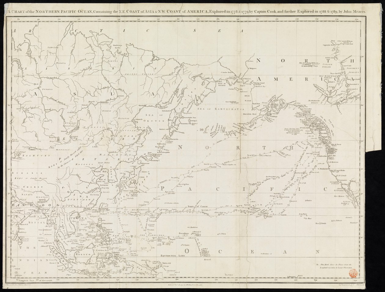
A Chart of the Northern Pacific Ocean Containing the NE Coast of Asia & NW Coast of America Explored in 1778 & 1779 by Captain Cook and Further Explored in 1788 & 1789 by John Meares by Unknown artist

A Chart of the Northern Pacific Ocean Containing the NE Coast of Asia & NW Coast of America Explored in 1778 & 1779 by Captain Cook and Further Explored in 1788 & 1789 by John Meares

(A chart of the Northern Pacific Ocean containing the NE coast of Asia & NW coast of America explored in 1778 & 1779 by Captain Cook and farther explored in 1788 & 1789 by John Meares (print))


Unknown artist

€ 0.00
Enthält ??% MwSt.
   Add to cart
   Configure art print
Undated  ·  print  ·  Picture ID: 1516497

Nonclassified artists

A Chart of the Northern Pacific Ocean Containing the NE Coast of Asia & NW Coast of America Explored in 1778 & 1779 by Captain Cook and Further Explored in 1788 & 1789 by John Meares by Unknown artist. Available as an art print on canvas, photo paper, watercolor board, uncoated paper or Japanese paper.
america (continent) · asia · cartography · north america · coast · ocean · black and white · print · mzprint ·
zu Favoriten hinzufügen   Add to favorites    Select wall color    View painting in a room AR/3D   View in 3D / AR
0 Reviews

Configure art print

Picture Frame

Medium & Stretcher

Glass & Passepartout

Miscellaneous & Extras

 Save / compare configuration
Preview Icon

Summary

Gemälde
Veredelung
Keilrahmen
Museumslizenz

€ ???.??
(inkl. 20% MwSt)
   Add to cart

Produktionszeit: 2-4 Werktage
Bildschärfe: PERFEKT

Should you desire adjustments to brightness and color, or a custom crop of the motif, we are happy to make these changes at no additional cost to you. Please do not hesitate to contact us.

Similar artworks selected for you

To the officers in the honourable East India Company The Euphrates and the Tigris from D A General Chart of the Island of Newfoundland with the Rocks & Soundings, Drawn from Surveys taken By James Cook and Michael Lane Map of the United States, 1816 Chart showing discoveries of Ross, Parry and Franklin in the Arctic during 1818-1827 Map of Cook A general chart of the Atlantic Ocean north of the Equator Frontispiece map from Chart of the search for Sir John Franklin and discovery of the North West Passage Finland and Russia, from Europe, describing all the changes of Territory, together with their deviations in the boundary lines of its several Empires and States agreed to and confirmed by the definitive treaty of Paris, 20th Nov. 1815, published 1816 A General Chart Exhibiting the Discoveries Made by Captain James Cook in This and His Two Preceding Voyages with the Tracks of the Ships Under His Command. By Lieutenant Roberts of His Majesty A Chart of the Atlantic or Western Ocean, showing the track of Nelson The Atlantic or Western Ocean from the West-India Atlas, 1775 Map of Part of the Western Coast of Celebes China Sea Singapore Strait by Staff Commander JW Reed Navg Lieuts TH Tizard... Assisted by the Officers of HMS Rifleman 1865-69 Discoveries in the Arctic Sea between Baffin Bay and Melville Island World map displaying the tracks of Captain Cook Map of the United States, 1816 General Map Covering North Pacific Ocean and Adjacent Coastal Regions The south west coast of Ireland from the Staggs of Castle Haven to Dursey I. Surveyed and navigated by M. Mackenzie Sen. 1775. The Chinese Empire, Chinese Tartary and the Kingdom of Korea, with the Islands of Japan, from Atlas de Toutes les Parties Connues du Globe Terrestre by Guillaume Raynal (1713-96) Published 1780 Coast of New England from Narragansett to Cape Cod Conway Harbour and Port Aylesbury, North American Atlantic Coast The Arctic Expedition, Map of the Smith Sound Route to the North Polar Sea New Map for the voyage to the North West coast of Africa, Anno, drawn and printed by Dean & Munday Chart of the Atlantic Ocean, with the British, French & Spanish settlements in North America and the West Indies Enlarged plan of Erebus and Terror Bay – The winter quarters of Sir John Franklin A Plan of the Navigable Canals now making in the Inland Parts of the Kingdom, for opening a Communication to the Ports of London, Bristol, Liverpool and Hull, with the adjacent Towns and Rivers. By James Brindley Engineer. Drawn by Rob.t Whitworth. An Account of the New Northern Archipelago Lately Discovered by the Russians
Show more similar artworks

Other art prints by Unknown artist

Revolutions 1848 - 1849: German National Assembly at St Paul Cartoon of Franz Liszt The Master Singers of Nuremberg: Eva Charlemagne (742-814), King of the Franks The Siege of Paris in 845 by the Vikings with Ragnar Lodbrok at Their Head Circus Maximus - The great circus or Circus Maximus, in Rome, with a chariot race Ned Land, Professor Aronnax and his servant Conseil look at the Giant Octopus through the porthole of the submarine Nautilus Engraving of the book by Jules Verne Twenty thousand leagues under the seas Martin Luther hanging his 95 theses in Wittenberg Napoleon at the Bivouac the Eve of the Battle of Austerlitz - engraving by Philippoteaux - Napoleon at the Bivouac. The Battle of Austerlitz (1805), also known as the Battle of the Three Emperors The land of cocagne: an imaginary land where one would live without work and without worry, in abundance and joy 20,000 leagues under the sea. Captain Nemo on the submarine Nautilus. Illustration from the novel by Jules Verne Twenty thousand leagues under the seas Torture of Michel Servet in Geneva, Spanish doctor and theologian - Engraving The Needle Rifle - Portrait of Otto Von Bismarck - Caricature Anonymous (around the 6th century). The oldest portrait of Saint Augustine (354 - 430). Rome. Palazzo Lateranense, Scala Santa (St. Staircase). Facsimile Portrait of Georg Philipp Telemann (1681-1767), German composer
Discover more works by Unknown artist

Excerpt from our top sellers

Blue Cave Reclining Female Nude with Spread Legs Two Girls Moon rising Over the Sea The Oceanids Mending the Sail, 1896 Christ in the House of His Parents, 1863 Lady with Peacock Fan Still Life with Cherries and Peaches Lamia The Stages of Life Arm of the Seine near Vétheuil The Interior of the Palm House Breakfast Time Napoleon I Bonaparte studying at the Royal Military School of Brienne. Its shadow falls on the geographic map of Europe. Illustration by Jacques Marie Gaston Onfray de Breville dit JOB
Show More Artworks


What our customers think about us


Frequently Asked Questions about Meisterdrucke


Personalizing your art print at Meisterdrucke is a simple and intuitive process that allows you to design an artwork exactly to your specifications: Choose a frame, determine the image size, decide on a printing medium, and add suitable glazing or a stretcher frame. We also offer customization options such as mats, fillets, and spacers. Our customer service is available to help you design your perfect artwork.

At Meisterdrucke, you have the fascinating option to visualize the artwork you configured directly in your own space. For a tailored preview, simply upload a photo of your room and let the artwork appear on it. If you visit us via a mobile device, be it a phone or tablet, our augmented reality feature brings the image to life and seamlessly projects it into your space. An experience that uniquely combines art and technology.

Choosing the medium is often a matter of personal taste. To give you a clearer idea, we have provided some images for each medium. For a holistic experience, we also offer you a sample set of all paper variants so you can make a decision not just visually but also haptically. You can take advantage of the sample set free of charge – only the shipping costs will apply. You can order the sample set directly.

Do not worry. At Meisterdrucke, we do not proceed mechanically. We manually review each order. If there are any inconsistencies or peculiarities in the configuration, we will immediately contact you. Of course, our courteous and patient support is always at your side to assist you with the configuration. Together with you, we adjust your image by phone or email so that the final result exactly meets your expectations.


Do you have any questions?

Are you interested in an art print from our manufactory but still unsure? Do you need advice on choosing the medium or help with the order?

Our experts are happy to assist you.

+43 4257 29415
support@meisterdrucke.com
Mo-Do: 7:00 - 16:00 | Fr: 7:00 - 13:00

Do you have any questions?

Are you interested in an art print from our manufactory but still unsure? Do you need advice on choosing the medium or help with the order?

Our experts are happy to assist you.

+43 4257 29415
support@meisterdrucke.com
Mo-Do: 7:00 - 16:00 | Fr: 7:00 - 13:00


Meisterdrucke

   Kärntner Strasse 46
        9586 Finkenstein am Faaker See
        Austria
        +43 4257 29415
        support@meisterdrucke.com
Other languages

                   
Erfahrungen & Bewertungen zu Meisterdrucke
Partner Logos

Kaiser Franz Joseph

Meisterdrucke
Kärntner Strasse 46
9586 Finkenstein am Faaker See · Austria
+43 4257 29415 · office@meisterdrucke.com
Partner Logos


(c) 2023 meisterdrucke.us