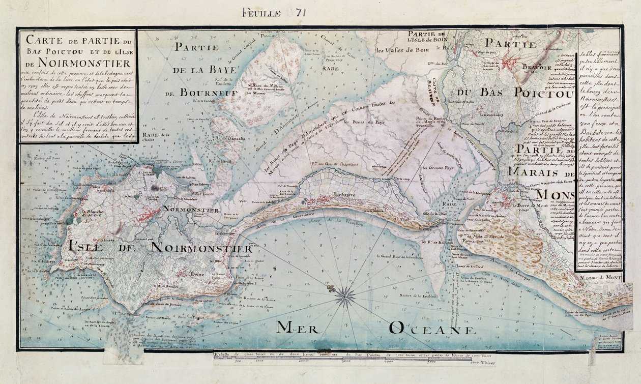
Map of part of Bas-Poitou and the Ile de Noirmoutier, 1703 by Claude Masse

Map of part of Bas-Poitou and the Ile de Noirmoutier, 1703

(Atlas 131 H.fol 71 Map of part of Bas-Poitou and the Ile de Noirmoutier, 1703 (pen, ink and wc on paper))


Claude Masse

€ 0.00
Enthält ??% MwSt.
   Add to cart
   Configure art print
1703  ·  pen, ink & watercolour on paper  ·  Picture ID: 37961

Nonclassified artists  ·  Cartography

Map of part of Bas-Poitou and the Ile de Noirmoutier, 1703 by Claude Masse. Available as an art print on canvas, photo paper, watercolor board, uncoated paper or Japanese paper.
noirmoutier · noirmoutier · noirmoutier-en-l' · c17th · c18th · island · vendee · pays-de-la-loire · lower poitou · Lower Poictou · Bibliotheque du Genie, Paris, France / Bridgeman Images
Other color variations of this picture  
zu Favoriten hinzufügen   Add to favorites    Select wall color    View painting in a room AR/3D   View in 3D / AR
0 Reviews

Configure art print

Picture Frame

Medium & Stretcher

Glass & Passepartout

Miscellaneous & Extras

 Save / compare configuration
Preview Icon

Summary

Gemälde
Veredelung
Keilrahmen
Museumslizenz

€ 112.27
(inkl. 20% MwSt)
   Add to cart

Bildschärfe: PERFEKT

Should you desire adjustments to brightness and color, or a custom crop of the motif, we are happy to make these changes at no additional cost to you. Please do not hesitate to contact us.

Similar artworks selected for you

The Bay of Concepcion, Chile Map of the Crimea and the Sea of Azov Plan of the departments of Arles Manuscript Map of the Southern Portion of the Red Sea from the Horn of Africa and Yemen up to Jiddah, c.1740 Chart of the North Sea: Norway to the Dover Straits, c.1700 (coloured engraving) Map of the Pacific Ocean Plano del Puerto y Rio Guayaquil en el Mar de el Sur Map of Bas Poitou, Pays d Map of the possessions of the republic of Genoa, including Corsica and Sardinia Map of New Discoveries in the North of the South Sea, East of Siberia and West of New France, 1731 Souter Point Lighthouse Map of Asia and America Map of Bombay with the harbour and country adjacent, also shown Arabian Sea and Persian Gulf Map of Panama Map of the North Atlantic Ocean, with the North Sea Black Sea, Chart of the South-West Coast of the Krimea from Cape Aia to Alma Bay. By the Officers of H.M.S.V. Spitfire. A correct chart of the east coast, from Hasbrough or Haisbrough Sand to Kingston upon Hull Map of Upper and Lower Bays of New York Harbor Map of the island of Noirmoutier accompanied by a map of the castle, made in 1769 England East Coast. Sheet 3 Map of Bas Poitou, Aunis and Saintonge with the Marshes of the Bay of Aiguillon in 1716 Map of Zeeland, Northern Part Map of the Gulf Stream The Battle of Viborg Bay, 1790 Map, 1790 Map of the Sea of Denmark Chart of Jamaica, Barbados, St Christopher, Martinique, Antigua and Bermuda Bay of Navarino General Chart of the Mediterranean
Show more similar artworks

Other art prints by Claude Masse

Map of Saint-Savinien on the Charente River in 1713, from Map of the Town of Lille, from Atlas 131 fol.13 Map of Saintes, Capital of Saintonge, from Map of Bas Poitou, Pays d Map of part of Bas-Poitou and the Ile de Noirmoutier, 1703 Map of Bas Poitou, Pays d Map of Saintes, capital of Saintonge, from Receuil des Plans de Saintonge, 1716 Plan of Noirmoutier-en-l Plan of the Chateau de Forgette, near Saint-Savinien, from Map of the towns and chateaux situated along the Charente River in 1714, from Recueil des Plans de Saintonge Map of the town of Tonnay-Boutonne, from Recueil des Plans de Saintonge Map of Bas Poitou, Aunis and Saintonge with the Marshes of the Bay of Aiguillon in 1716 Plan of Saarlouis, from Traite de Fortifications Map of Saintonge, from Recueil des Plans de Saintonge Construction of a Town Square and the Tools Used
Discover more works by Claude Masse

Other motives from the category Cartography

Ireland (detail) from a Renaissance map of Europe, 1528 Map of South-Eastern Asia and Northern Australia Map of Corsica Map of Africa, from Map of Cochin, India Copy of Catalan Map of Europe, North Africa and the Middle East Europe and Central Asia, from an Atlas of the World in 33 Maps, Venice, 1st September 1553 Map of the Battle of Borodino, Published by William Blackwood and Sons, Edinburgh and London, 1848 Double Hemisphere World Map Map of the Passage of the Beresina, published by William Blackwood and Sons, Edinburgh and London, 1848 Map of the Valley of Mexico at the Time of the Conquest, from History of The Conquest of Mexico, published 1850 Map of Animals in Africa Map of Poznan and Gruczno, from Map of the Battle of Trafalgar, published by William Blackwood and Sons, Edinburgh and London
View More from "Cartography"

Excerpt from our top sellers

The Singing Man After the Bath Poplars on the River Epte The Fourth Estate Judith Beheading Holofernes Wiltshire Landscape, 1937 The Embrace Rosa: Bengale the Hymenes, from Illustration for Milton The Family The Goldfinch Red Tree Free Curve to the Point - Accompanying Sound of Geometric Curves View of Florence Luncheon of the Boating Party
Show More Artworks


What our customers think about us


Frequently Asked Questions about Meisterdrucke


Personalizing your art print at Meisterdrucke is a simple and intuitive process that allows you to design an artwork exactly to your specifications: Choose a frame, determine the image size, decide on a printing medium, and add suitable glazing or a stretcher frame. We also offer customization options such as mats, fillets, and spacers. Our customer service is available to help you design your perfect artwork.

At Meisterdrucke, you have the fascinating option to visualize the artwork you configured directly in your own space. For a tailored preview, simply upload a photo of your room and let the artwork appear on it. If you visit us via a mobile device, be it a phone or tablet, our augmented reality feature brings the image to life and seamlessly projects it into your space. An experience that uniquely combines art and technology.

Choosing the medium is often a matter of personal taste. To give you a clearer idea, we have provided some images for each medium. For a holistic experience, we also offer you a sample set of all paper variants so you can make a decision not just visually but also haptically. You can take advantage of the sample set free of charge – only the shipping costs will apply. You can order the sample set directly.

Do not worry. At Meisterdrucke, we do not proceed mechanically. We manually review each order. If there are any inconsistencies or peculiarities in the configuration, we will immediately contact you. Of course, our courteous and patient support is always at your side to assist you with the configuration. Together with you, we adjust your image by phone or email so that the final result exactly meets your expectations.


Do you have any questions?

Are you interested in an art print from our manufactory but still unsure? Do you need advice on choosing the medium or help with the order?

Our experts are happy to assist you.

+43 4257 29415
support@meisterdrucke.com
Mo-Do: 7:00 - 16:00 | Fr: 7:00 - 13:00

Do you have any questions?

Are you interested in an art print from our manufactory but still unsure? Do you need advice on choosing the medium or help with the order?

Our experts are happy to assist you.

+43 4257 29415
support@meisterdrucke.com
Mo-Do: 7:00 - 16:00 | Fr: 7:00 - 13:00


Meisterdrucke

   Kärntner Strasse 46
        9586 Finkenstein am Faaker See
        Austria
        +43 4257 29415
        support@meisterdrucke.com
Other languages

                   
Erfahrungen & Bewertungen zu Meisterdrucke
Partner Logos

Kaiser Franz Joseph

Meisterdrucke
Kärntner Strasse 46
9586 Finkenstein am Faaker See · Austria
+43 4257 29415 · office@meisterdrucke.com
Partner Logos


(c) 2025 meisterdrucke.us