Search by artist, work title or style – e.g. Monet, Starry Night, Impressionism, Hokusai wave, nude. Describe the scene – e.g. green meadow, abstract with lots of red, dark oil painting, standing nude next to a tree.

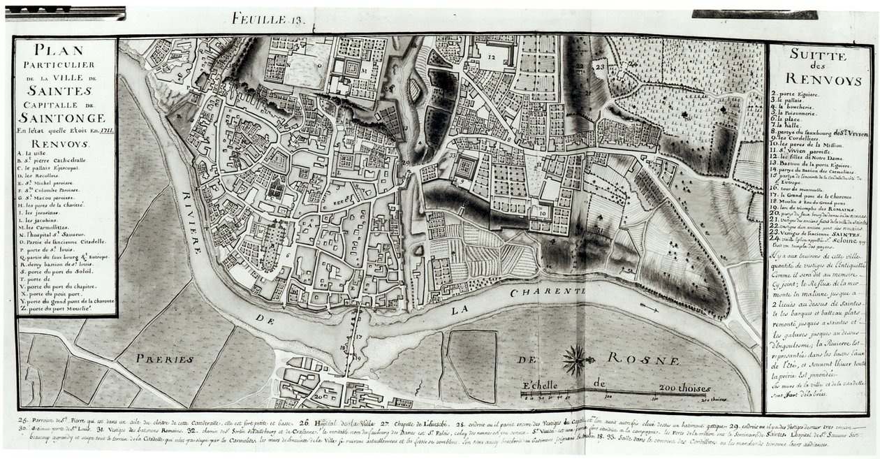
Atlas 131 fol.13 Map of Saintes, Capital of Saintonge, from

Atlas 131 fol.13 Map of Saintes, Capital of Saintonge, from 'Recueil des Plans de Saintonge', 1711

(Atlas 131 fol.13 Map of Saintes, capital of Saintonge, from 'Recueil des Plans de Saintonge', 1711 (pen und ink and wc on paper) )


Claude Masse

€ 105.73
Enthält 0% MwSt.
   Configure art print
1711  ·  pen & ink and watercolour on paper  ·  Picture ID: 41384

Nonclassified artists  ·  Cartography

Atlas 131 fol.13 Map of Saintes, Capital of Saintonge, from 'Recueil des Plans de Saintonge', 1711 by Claude Masse. Available as an art print on canvas, photo paper, watercolor board, uncoated paper or Japanese paper.
charente river · aerial view · fields · drawing · province of western france · region · plan · irrigation · streets · Min. Defense - Service Historique de l'Armee de Terre,France / Bridgeman Images
AR/3D   View in 3D / AR zu Favoriten hinzufügen   Add to favorites    Select wall color    View painting in a room
0 Reviews

Configure art print

Picture Frame

Medium & Stretcher

Glass & Passepartout

Miscellaneous & Extras

 Save / compare configuration
Preview Icon

Summary

Gemälde
Veredelung
Keilrahmen
Museumslizenz

€ 105.73
(inkl. 20% MwSt)
   Add to cart

Bildschärfe: PERFEKT

Should you desire adjustments to brightness and color, or a custom crop of the motif, we are happy to make these changes at no additional cost to you. Please do not hesitate to contact us.

Similar artworks selected for you

Map of the town of Tonnay-Boutonne, from Recueil des Plans de Saintonge Plan of Richmond, Syon and Kew Nuova pianta di Roma by Giambattista Nolli, 1748, known as La Pianta Grande di Roma Map of Saintes, capital of Saintonge, from Receuil des Plans de Saintonge, 1716 Plan of the Cities of London and Westminster and Borough of Southwark, Engraved by John Tinney, Published 1746 Map of Rome. Lower Right Part Hollar Loggan The Saint-Germain village, facsimile of the plan by Gomboust, 1652 A Map of The King Map of Berlin and Coelln, 1652 Map of Saint-Savinien on the Charente River in 1713, from Siege of Menen, 1706 Promenades or Itineraries of the Gardens of Chantilly Interactive Viewer Map of the West End of London A map of the City and Suburbs of Cork Siege of Bonn, 1703 Siege of Mons, 1709 Siege of Kaiserswerth, 1702 Plan of the City of Kaiserswerth A Map of Bloomsbury and Holborn, London Turin, Italy Map of the City of Florence Mainz Plan Nuova pianta di Roma by Giambattista Nolli, 1748, known as La Pianta Grande di Roma Part of Bernard Ratzer Map of Dusseldorf, 1797 Siege of Béthune, 1710 Map of St Clements Danes and St Mary Savoy, London, with the Rolls Liberty and Lincolns Inn
Show more similar artworks

Other art prints by Claude Masse

Map of Saint-Savinien on the Charente River in 1713, from Atlas 131 fol.13 Map of Saintes, Capital of Saintonge, from Plan of the Chapus Fort, from Map of the Town of Lille, from Cross-section and Elevation of the Harbour Tower at Toulon, from Plan of the Chateau de Forgette, near Saint-Savinien, from Plan of Noirmoutier-en-l Map of Bas Poitou, Pays d Different Species of Tree and Sawing Logs, from Fort of Saint-Sauveur, Lille, in 1728, from Map of Bas Poitou, Aunis and Saintonge with the Marshes of the Bay of Aiguillon in 1716 Citadel of Saint-Jean de Port in 1689, from Traite de Fortifications Map of Bas Poitou, Pays d Map of part of Bas-Poitou and the Ile de Noirmoutier, 1703 Map of the town of Tonnay-Boutonne, from Recueil des Plans de Saintonge
Discover more works by Claude Masse

Other motives from the category Cartography

Map of Warsaw, from Map of Syria, Mesopotamia, Assyria, from Map of Cutch and Kathiawar, published under the direction of Colonel G.C. de Pree, S.C., Surveyor General of India, 1885 Map of the Battle of Talavera, Published by William Blackwood and Sons, Edinburgh and London, 1848 Map of Europe Map of Animals in Europe Map Showing the Geography of the Hebrews and Exhibiting the Dispersion of the Descendants of Noah Ms. 988 Vol.3, fol.61 Map of the Prussian States in 1799 Map of the Battle of the Nile, published by William Blackwood and Sons, Edinburgh and London, 1848 Londinium Antiqua, map of London, published by William Darton, 1563 Map Depicting the East Coast of North America, 1647 A Map inspired by Candide by Francois Voltaire for a competition organised by the Ecole Nationale des Ponts et Chaussees in Paris The Pacific Ocean, from an Atlas of the World in 33 Maps, Venice, 1st September 1553 Map of Laos and the Mekong River Showing the Route of the Voyage of Henri Mouhot, Illustration from Travels in the Central Parts of Indo-China (Siam), Cambodia, and Laos During the Years 1858, 1859
View More from "Cartography"

Excerpt from our top sellers

Woman in a Yellow Dress The River of Light Richelieu (1585-1642) on the Sea Wall at La Rochelle, 1881 On the Sailboat The Meurthe Boating Party Annunciation (post restoration) Profile Portrait of a Young Woman A Guardian Angel Protects Two Children Crossing a River on an Old Wooden Bridge, Early 20th Century Lucifer Tetrahedra Isle of the Dead Pillars of Creation (NIRCam and MIRI Composite) Adele Bloch-Bauer The Birth of Venus (edited) The Waterlily Pond with the Japanese Bridge
Show More Artworks


What our customers think about us


Frequently Asked Questions about Meisterdrucke


Personalizing your art print at Meisterdrucke is a simple and intuitive process that allows you to design an artwork exactly to your specifications: Choose a frame, determine the image size, decide on a printing medium, and add suitable glazing or a stretcher frame. We also offer customization options such as mats, fillets, and spacers. Our customer service is available to help you design your perfect artwork.

At Meisterdrucke, you have the fascinating option to visualize the artwork you configured directly in your own space. For a tailored preview, simply upload a photo of your room and let the artwork appear on it. If you visit us via a mobile device, be it a phone or tablet, our augmented reality feature brings the image to life and seamlessly projects it into your space. An experience that uniquely combines art and technology.

Choosing the medium is often a matter of personal taste. To give you a clearer idea, we have provided some images for each medium. For a holistic experience, we also offer you a sample set of all paper variants so you can make a decision not just visually but also haptically. You can take advantage of the sample set free of charge – only the shipping costs will apply. You can order the sample set directly.

Do not worry. At Meisterdrucke, we do not proceed mechanically. We manually review each order. If there are any inconsistencies or peculiarities in the configuration, we will immediately contact you. Of course, our courteous and patient support is always at your side to assist you with the configuration. Together with you, we adjust your image by phone or email so that the final result exactly meets your expectations.


Do you have any questions?

Are you interested in an art print from our manufactory but still unsure? Do you need advice on choosing the medium or help with the order?

Our experts are happy to assist you.

+43 4257 29415
support@meisterdrucke.com
Mo-Do: 7:00 - 16:00 | Fr: 7:00 - 13:00

Do you have any questions?

Are you interested in an art print from our manufactory but still unsure? Do you need advice on choosing the medium or help with the order?

Our experts are happy to assist you.

+43 4257 29415
support@meisterdrucke.com
Mo-Do: 7:00 - 16:00 | Fr: 7:00 - 13:00


Meisterdrucke

   Kärntner Strasse 46
        9586 Finkenstein am Faaker See
        Austria
        +43 4257 29415
        support@meisterdrucke.com
Other languages

                   
Erfahrungen & Bewertungen zu Meisterdrucke
Post.at DHL Express Quehenberger Cargoboard
Kaiser Franz Joseph

Meisterdrucke
Kärntner Strasse 46
9586 Finkenstein am Faaker See · Austria
+43 4257 29415 · office@meisterdrucke.com
Post.at DHL Express Quehenberger Cargoboard


Meisterdrucke 2764 Bewertungen auf ProvenExpert.com

(c) 2025 meisterdrucke.us