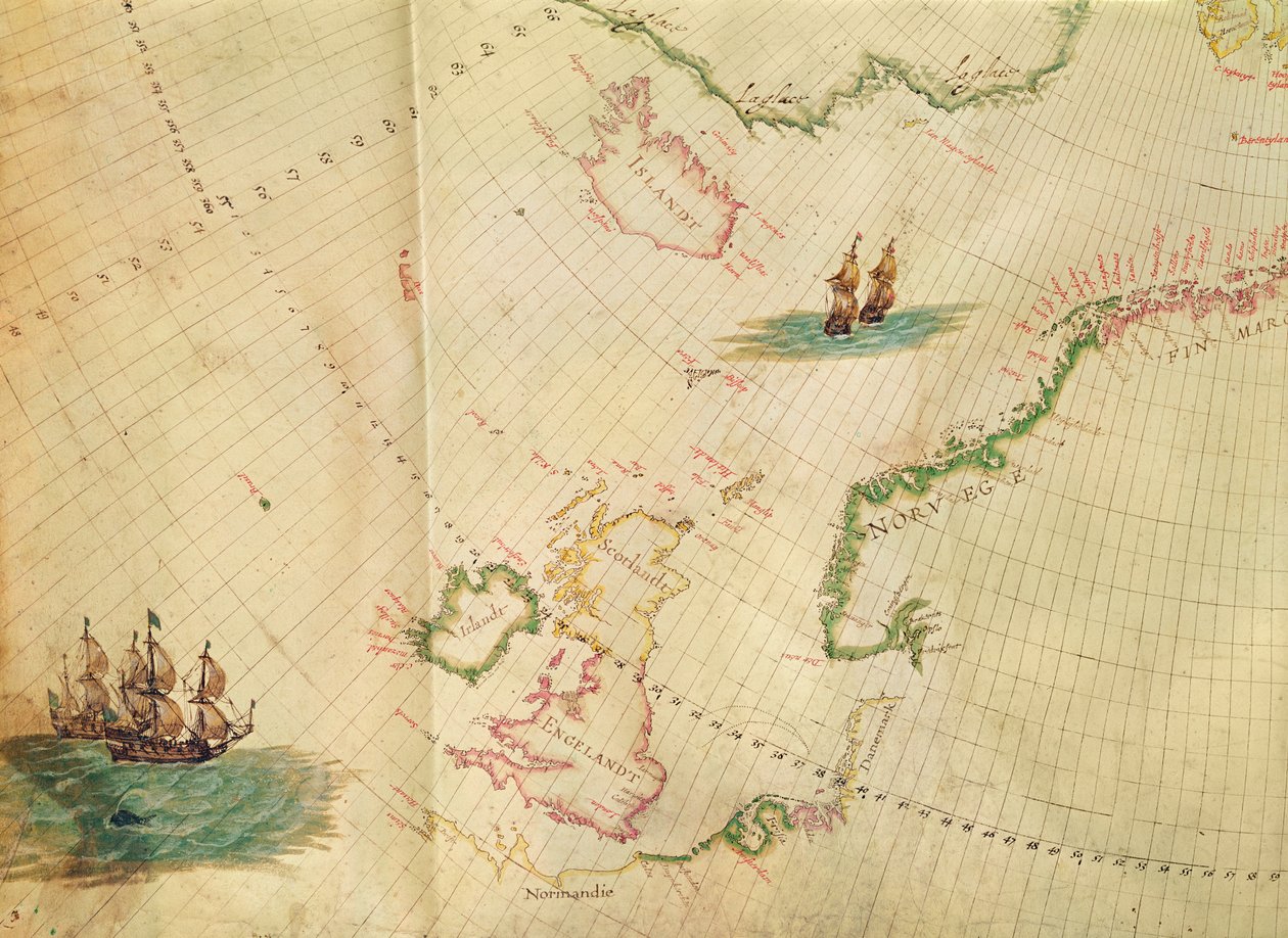
The Polar Aurora, from a Collection of Dutch Marine Maps (detail) by Hessel Gerritsz

The Polar Aurora, from a Collection of Dutch Marine Maps (detail)

(Ms. 1288 fol. 1 The Polar Aurora, detail of England, Ireland and Norway, from a Collection of Dutch Marine Maps engraving)


Hessel Gerritsz

€ 117.55
Enthält 0% MwSt.
   Configure art print
Undated  ·  engraving  ·  Picture ID: 356711

Nonclassified artists  ·  Cartography

The Polar Aurora, from a Collection of Dutch Marine Maps (detail) by Hessel Gerritsz. Available as an art print on canvas, photo paper, watercolor board, uncoated paper or Japanese paper.
latitude · longitude · north pole · iceland · great britain · united kingdom · british isles · country · countries · aerial view · nautical · discovery · exploration · islands · boats · ships · scandinavia · aurora borealis · northern lights · astronomy · arctic · natural phenomenon · Bibliotheque de l'Institut de France, Paris, France / Bridgeman Images
zu Favoriten hinzufügen   Add to favorites    Select wall color    View painting in a room AR/3D   View in 3D / AR
0 Reviews

Configure art print

Picture Frame

Medium & Stretcher

Glass & Passepartout

Miscellaneous & Extras

 Save / compare configuration
Preview Icon

Summary

Gemälde
Veredelung
Keilrahmen
Museumslizenz

€ 117.55
(inkl. 20% MwSt)
   Add to cart

Bildschärfe: PERFEKT

Should you desire adjustments to brightness and color, or a custom crop of the motif, we are happy to make these changes at no additional cost to you. Please do not hesitate to contact us.

Similar artworks selected for you

The Polar Aurora, from a Pascaart van de Noort Zee verthoonende in zich alle de Custen en havens daer rontom gelegen The Famous West Indian Voyage Made by the English Fleet of 23 Ships and Barks Map of Africa, India, Indian Ocean and East Indies A general chart of the northern navigation A chart of the coast of America from Newfoundland to Cape Cod East Indies: Sea and coastal chart extending from Southern India to Japan by the way of the East Indian archipelago The Windward Passage from Jamaica, Between the East End of Cuba, and the West End of Hispaniola A chart of the North Sea A Chart Bound in Van Keulen A chart of the easternmost part of the East Indies with all the adjacent islands from Cape Comorin to Japan A chart of the sea coasts of England, Flanders and Holland, c.1672 The Caribbean Sea: The Bermuda Triangle between the Bermuda Archipelago, Miami, and Puerto Rico. According to Wilhelm Blaeu Chart of southern Mediterranean and Adriatic Map of the Pacific, China and America, 1589 Western Atlantic Ocean A chart of the easternmost part of the East Indies with all the adjacent islands from Cape Comorin to Japan Map of Eastern North America: Florida to Chesapeake Bay Chart of New Holland, Virginia and New England Mainland Southeast Asia, detail from a world atlas A Double-Page Map of the Atlantic Ocean, Showing the East Coast of North and South America Map of the Sea of Maluku, from the Cosmographie Universelle Map of Northern Europe Pas-caert van de Canael, Tusschen Engelandt en Vranckryck, van Pleymuyen tot an de Sorlinges, als mede van Portbimel tot aen Heyssant European Coast, Map on Parchment by Willem and Joan Blaeu East Indies, from Chart of the Mediterranean, Showing Italy and the North African Coast The New Great Luminous Sea Torch: The Sixth Volume: Showing the Sea-Coasts, Islands and Ports of Eastern Europe Map of East Africa and Madagascar
Show more similar artworks

Other art prints by Hessel Gerritsz

The Polar Aurora, from a Collection of Dutch Marine Maps (detail) The Polar Aurora, from a Walrus at Spitsbergen Title Page for Loenersloot - Summer, from The Seasons, View of Castles in the Vicinity of Amsterdam Maersen - Autumn, from The Seasons, View of Castles in the Vicinity of Amsterdam Activities on the Ice Before Zuylen Castle Nyenroy - Spring, from The Seasons, View of Castles in the Vicinity of Amsterdam Zuylen - Winter, from The Seasons, View of Castles in the Vicinity of Amsterdam
Discover more works by Hessel Gerritsz

Other motives from the category Cartography

Map Illustrating La Rochelle Occupied by the Huguenots World Map Map of the Kingdom of Juida, or Whidah Map of Asia, Tartaria, Japan, the Philippines and the East Indies, engraved by G. van Gouwen, c.1690 Map of Sixteenth Century Britain and Northern France, from the Map of Cumberland Map of the Suez Canal, c.1870 Map of Rome Seat of War in the Crimea, Map of the Country between Simpheropol and Baidar to Illustrate the Movements of the Allied and Russian Armies Map of the New Simplon Pass, 1803 Map of Russia and Eastern Europe from Atlas Minor, 1745 Map of the Battle of Montmirail, published by William Blackwood and Sons, Edinburgh and London, 1848 Map of Tartary Map of Persia Phenomena of Aratus, cosmological diagram
View More from "Cartography"

Excerpt from our top sellers

The Great Wave off Kanagawa Blue Horse I Olive Trees with Yellow Sky and Sun The Great Wave off Kanagawa (from the series Beethoven Frieze Circles in a Circle The Starry Night, June 1889 Richelieu (1585-1642) on the Sea Wall at La Rochelle, 1881 The Wild Rabbit Poster, 1899 Untitled No. 1 from a Series of Altar Paintings The Fall of the Damned Vertumnus Effect of Spring, Giverny, 1890 Paradiso, Canto 31: The saintly throng form a rose in the empyrean Seated Woman with Raised Knee
Show More Artworks


What our customers think about us


Frequently Asked Questions about Meisterdrucke


Personalizing your art print at Meisterdrucke is a simple and intuitive process that allows you to design an artwork exactly to your specifications: Choose a frame, determine the image size, decide on a printing medium, and add suitable glazing or a stretcher frame. We also offer customization options such as mats, fillets, and spacers. Our customer service is available to help you design your perfect artwork.

At Meisterdrucke, you have the fascinating option to visualize the artwork you configured directly in your own space. For a tailored preview, simply upload a photo of your room and let the artwork appear on it. If you visit us via a mobile device, be it a phone or tablet, our augmented reality feature brings the image to life and seamlessly projects it into your space. An experience that uniquely combines art and technology.

Choosing the medium is often a matter of personal taste. To give you a clearer idea, we have provided some images for each medium. For a holistic experience, we also offer you a sample set of all paper variants so you can make a decision not just visually but also haptically. You can take advantage of the sample set free of charge – only the shipping costs will apply. You can order the sample set directly.

Do not worry. At Meisterdrucke, we do not proceed mechanically. We manually review each order. If there are any inconsistencies or peculiarities in the configuration, we will immediately contact you. Of course, our courteous and patient support is always at your side to assist you with the configuration. Together with you, we adjust your image by phone or email so that the final result exactly meets your expectations.


Do you have any questions?

Are you interested in an art print from our manufactory but still unsure? Do you need advice on choosing the medium or help with the order?

Our experts are happy to assist you.

+43 4257 29415
support@meisterdrucke.com
Mo-Do: 7:00 - 16:00 | Fr: 7:00 - 13:00

Do you have any questions?

Are you interested in an art print from our manufactory but still unsure? Do you need advice on choosing the medium or help with the order?

Our experts are happy to assist you.

+43 4257 29415
support@meisterdrucke.com
Mo-Do: 7:00 - 16:00 | Fr: 7:00 - 13:00


Meisterdrucke

   Kärntner Strasse 46
        9586 Finkenstein am Faaker See
        Austria
        +43 4257 29415
        support@meisterdrucke.com
Other languages

                   
Erfahrungen & Bewertungen zu Meisterdrucke
Partner Logos

Kaiser Franz Joseph

Meisterdrucke
Kärntner Strasse 46
9586 Finkenstein am Faaker See · Austria
+43 4257 29415 · office@meisterdrucke.com
Partner Logos


(c) 2025 meisterdrucke.us