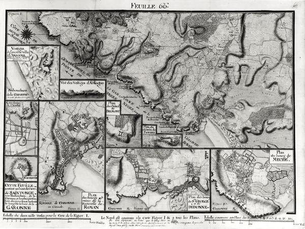
Map of Saintonge, from Recueil des Plans de Saintonge by Claude Masse

Map of Saintonge, from Recueil des Plans de Saintonge

(Fol.66 Map of Saintonge, from Recueil des Plans de Saintonge (pen & ink and wc on paper) )


Claude Masse

€ 115.42
Enthält 0% MwSt.
   Configure art print
Undated  ·  pen & ink and watercolour on paper  ·  Picture ID: 575413

Nonclassified artists

Map of Saintonge, from Recueil des Plans de Saintonge by Claude Masse. Available as an art print on canvas, photo paper, watercolor board, uncoated paper or Japanese paper.
province of western france · garonne river · meche · didonne · royan · ansogne · aerial view · region · boubes · belmont · castle · castles · st. augustine · notre dame de paradis · st. george · geography · Min. Defense - Service Historique de l'Armee de Terre,France / Bridgeman Images
zu Favoriten hinzufügen   Add to favorites    Select wall color    View painting in a room AR/3D   View in 3D / AR
0 Reviews

Configure art print

Picture Frame

Medium & Stretcher

Glass & Passepartout

Miscellaneous & Extras

 Save / compare configuration
Preview Icon

Summary

Gemälde
Veredelung
Keilrahmen
Museumslizenz

€ 115.42
(inkl. 20% MwSt)
   Add to cart

Bildschärfe: PERFEKT

Should you desire adjustments to brightness and color, or a custom crop of the motif, we are happy to make these changes at no additional cost to you. Please do not hesitate to contact us.

Similar artworks selected for you

Map of the towns and chateaux situated along the Charente River in 1714, from Recueil des Plans de Saintonge Map (from Beauvais to Senlis) of Cassini Prepared by the Cassini Family, Especially by Cesar-François Cassini (Cassini III) and His Son Jean-Dominique Cassini (Cassini IV). The Leves were Made between 1756 and 1789 and the 181 Sheets of the Map were Publis The Battle of Falkirk, 28 January 1746 Map of Bas Poitou, Aunis and Saintonge with the Marshes of the Bay of Aiguillon in 1716 Seat of War in the Crimea, Map of the Country between Simpheropol and Baidar to Illustrate the Movements of the Allied and Russian Armies Preparatory Map of the Suez Canal, 1855 Map Of The World Map of the Operations of the American Army in the Valley of Mexico in August and September 1847 during the Mexican-American War Plans of the Principal Towns, Forts and Harbours in Ireland, illustration from The Cottoniana or Anglo-Saxon Map MS Tib. BV Map of North-East China, Showing the Gulf of Pechili, the Tien-Tsin (Peiho) River, and the Approaches to Pekin Chart of the Arctic Regions Showing the North West Passage Connecting the Atlantic and Pacific Oceans The Course of the River Amazon Wolfe Picturesque Journey through the Isthmus of Suez (Plan of Suez) in Map of Toulon (France) Universale World Map The capture of the Prussian fortress of Kolberg on 16 December 1761 A plan of New York Island, with part of Long Island, Staten Island and East New Jersey, with a particular description of the engagement on the woody heights of Long Island between Flatbush and Brooklyn Map of St. Petersburg, c.1750 The Atlantic Neptune The Atlantic Neptune Map of the Borders of European Russia with Turkey, from the Mouths of the Danube to the Caucasus Map of Amsterdam and Surrounding Areas A Correct Plan of the environs of Quebec and of the battle fought on 13th September, 1759 Plan of New York Island with Part of Long Island, Staten Island and East New Jersey and the Engagement on the Woody Heights of Long Island between the British Forces, under the command of General Sir William Howe Map of European Russia showing its Earliest Extent, its Encroachments upon Adjacent Countries, and the Present Boundary of the Empire Map of the Suez Canal, c.1870 Port Mahon and Fort St Philip, Spain
Show more similar artworks

Other art prints by Claude Masse

Map of Saint-Savinien on the Charente River in 1713, from Map of the Town of Lille, from Atlas 131 fol.13 Map of Saintes, Capital of Saintonge, from Map of Bas Poitou, Pays d Map of part of Bas-Poitou and the Ile de Noirmoutier, 1703 Map of Bas Poitou, Pays d Map of Saintes, capital of Saintonge, from Receuil des Plans de Saintonge, 1716 Plan of Noirmoutier-en-l Map of the towns and chateaux situated along the Charente River in 1714, from Recueil des Plans de Saintonge Plan of the Chateau de Forgette, near Saint-Savinien, from Map of Bas Poitou, Aunis and Saintonge with the Marshes of the Bay of Aiguillon in 1716 Map of the town of Tonnay-Boutonne, from Recueil des Plans de Saintonge Plan of Saarlouis, from Traite de Fortifications Map of Saintonge, from Recueil des Plans de Saintonge Construction of a Town Square and the Tools Used
Discover more works by Claude Masse

Excerpt from our top sellers

Sunset Over the Lake Women of Tahiti, On the Beach, 1891 Pandemonium Adele Bloch-Bauer Portrait of the philosopher and esotericist Rudolf Steiner Reduced Weight The Temptation of St. Anthony, right hand panel, detail of a couple riding a fish The Blue Rigi: Lake of Lucerne - Sunrise Dream of Arcadia Praying Hands The Dragon among Clouds Nuda Veritas Moonrise by the Sea King of the Forest, 1878 The Great Wave off Kanagawa
Show More Artworks


What our customers think about us


Frequently Asked Questions about Meisterdrucke


Personalizing your art print at Meisterdrucke is a simple and intuitive process that allows you to design an artwork exactly to your specifications: Choose a frame, determine the image size, decide on a printing medium, and add suitable glazing or a stretcher frame. We also offer customization options such as mats, fillets, and spacers. Our customer service is available to help you design your perfect artwork.

At Meisterdrucke, you have the fascinating option to visualize the artwork you configured directly in your own space. For a tailored preview, simply upload a photo of your room and let the artwork appear on it. If you visit us via a mobile device, be it a phone or tablet, our augmented reality feature brings the image to life and seamlessly projects it into your space. An experience that uniquely combines art and technology.

Choosing the medium is often a matter of personal taste. To give you a clearer idea, we have provided some images for each medium. For a holistic experience, we also offer you a sample set of all paper variants so you can make a decision not just visually but also haptically. You can take advantage of the sample set free of charge – only the shipping costs will apply. You can order the sample set directly.

Do not worry. At Meisterdrucke, we do not proceed mechanically. We manually review each order. If there are any inconsistencies or peculiarities in the configuration, we will immediately contact you. Of course, our courteous and patient support is always at your side to assist you with the configuration. Together with you, we adjust your image by phone or email so that the final result exactly meets your expectations.


Do you have any questions?

Are you interested in an art print from our manufactory but still unsure? Do you need advice on choosing the medium or help with the order?

Our experts are happy to assist you.

+43 4257 29415
support@meisterdrucke.com
Mo-Do: 7:00 - 16:00 | Fr: 7:00 - 13:00

Do you have any questions?

Are you interested in an art print from our manufactory but still unsure? Do you need advice on choosing the medium or help with the order?

Our experts are happy to assist you.

+43 4257 29415
support@meisterdrucke.com
Mo-Do: 7:00 - 16:00 | Fr: 7:00 - 13:00


Meisterdrucke

   Kärntner Strasse 46
        9586 Finkenstein am Faaker See
        Austria
        +43 4257 29415
        support@meisterdrucke.com
Other languages

                   
Erfahrungen & Bewertungen zu Meisterdrucke
Partner Logos

Kaiser Franz Joseph

Meisterdrucke
Kärntner Strasse 46
9586 Finkenstein am Faaker See · Austria
+43 4257 29415 · office@meisterdrucke.com
Partner Logos


(c) 2025 meisterdrucke.us