Search by artist, work title or style – e.g. Monet, Starry Night, Impressionism, Hokusai wave, nude. Describe the scene – e.g. green meadow, abstract with lots of red, dark oil painting, standing nude next to a tree.

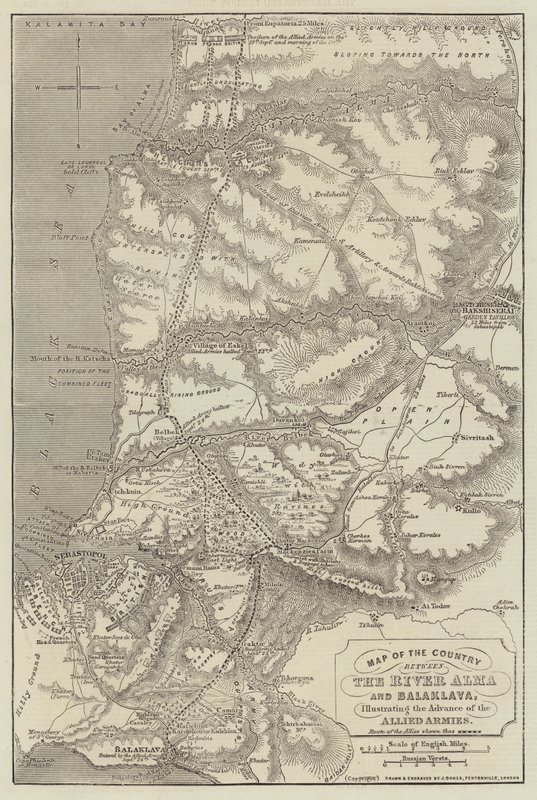
Map of the Country between the River Alma and Balaklava, illustrating the Advance of the Allied Armies by John Dower

Map of the Country between the River Alma and Balaklava, illustrating the Advance of the Allied Armies

(Map of the Country between the River Alma and Balaklava, illustrating the Advance of the Allied Armies )


John Dower

€ 127.55
Enthält 0% MwSt.
   Configure art print
1855  ·  Gravur  ·  Picture ID: 251399

Nonclassified artists  ·  Cartography

Map of the Country between the River Alma and Balaklava, illustrating the Advance of the Allied Armies by John Dower. Available as an art print on canvas, photo paper, watercolor board, uncoated paper or Japanese paper.
Private Collection / Bridgeman Images / Look and Learn
AR/3D   View in 3D / AR zu Favoriten hinzufügen   Add to favorites    Select wall color    View painting in a room
0 Reviews

Configure art print

Picture Frame

Medium & Stretcher

Glass & Passepartout

Miscellaneous & Extras

 Save / compare configuration
Preview Icon

Summary

Gemälde
Veredelung
Keilrahmen
Museumslizenz

€ 127.55
(inkl. 20% MwSt)
   Add to cart

Bildschärfe: PERFEKT

Should you desire adjustments to brightness and color, or a custom crop of the motif, we are happy to make these changes at no additional cost to you. Please do not hesitate to contact us.

Similar artworks selected for you

Map of North-East China, Showing the Gulf of Pechili, the Tien-Tsin (Peiho) River, and the Approaches to Pekin Map Showing the New Frontier Line Between Russia and Turkey as Settled by the Treaty, 30 March 1856 Map of the Seat of War in Virginia Map of the Country between Auckland and the River Waikato, New Zealand, illustrating the War with the Natives Sketch to illustrate the Battle of Dunbar, 1650 Seat of War in the Crimea, Map of the Country between Simpheropol and Baidar to Illustrate the Movements of the Allied and Russian Armies Plan of the Anse de l Map of the Fens as Drained in 1830 Plan of Sebastopol, showing the Forts and Public Buildings the Position of the Allied Armies in Winter Quarters Map illustrating General Lee Italian advance, August 1917 Map of Lower Egypt, Showing the Lines of Railway and Projected Isthmus of Suez Canal Map of the New Fortifications of Antwerp Maps of Africa, Upper Guinea, and the Gold Coast, Showing the Site of the Ashantee War Map of the Island of Jamaica Windsor Simonoseki Bay, Japan Wilmington and Cape Fear River, North Carolina Map of the Caucasus The Gallipoli Campaign, First World War, 1915 Map of Greater New York Allied Positions on the Gallipoli Peninsula in Turkey, First World War, July 1915, c1920 Reading Map of the City of Ancient Rome During Its Greatness, BC 30-AD 400 Map of Asia Minor, Expedition of Cyrus the Younger, and Retreat of the Ten Thousand Map of the Shipka Pass over the Balkans Plan of Ladysmith and Chronicle of Events, 1900 Abyssinia, Showing the Route of the British Forces A Map of Cadiz
Show more similar artworks

Other art prints by John Dower

Plan of Constantinople and its Suburbs Map of the Ottoman Empire, Kingdom of Greece, and the Russian Provinces on the Black Sea Map of North-East China, Showing the Gulf of Pechili, the Tien-Tsin (Peiho) River, and the Approaches to Pekin Map of the Strait of Malacca The Route of Burke and Wills across the Continent of Australia from Cooper Map of Lower Egypt, Showing the Lines of Railway and Projected Isthmus of Suez Canal Map of European Russia showing its Earliest Extent, its Encroachments upon Adjacent Countries, and the Present Boundary of the Empire Maps of Africa, Upper Guinea, and the Gold Coast, Showing the Site of the Ashantee War Map Showing the New Frontier Line Between Russia and Turkey as Settled by the Treaty, 30 March 1856 Map Illustrating General Sherman Map of the Country between the River Alma and Balaklava, illustrating the Advance of the Allied Armies Map of India, Showing the Railways Finished, in Progress and Intended, the Cotton and Coal Districts Map of Austria and the German Empire Map of the Country between Auckland and the River Waikato, New Zealand, illustrating the War with the Natives Seat of War in the Crimea, Map of the Country between Simpheropol and Baidar to Illustrate the Movements of the Allied and Russian Armies
Discover more works by John Dower

Other motives from the category Cartography

Receipt for Maple & Company Ltd Map of Barbados Map of Lime Street Ward, London The Petit Chatelet and its surroundings around 1540, after the tapestry plan Map of Asia, Tartaria, Japan, the Philippines and the East Indies, engraved by G. van Gouwen, c.1690 Map of the City and Portuguese Port of Goa, India (detail) A Sailing Ship Firing Its Cannon, Detail from a Map of the Pacific, China and America, 1599 Map of the South of Russia and Azerbaijan Map of part of Bas-Poitou and the Ile de Noirmoutier, 1703 Map of the Siege of St. Jean d Fol.13 Map of South America and the Magellan Straits, from an Atlas, 1571 Cartouche from Map of Bristol, from Map of the route followed by Hernando Cortes during the conquest of Mexico Map of the Magellan Straits, Patagonia
View More from "Cartography"

Excerpt from our top sellers

The River of Light Ruby, Gold and Malachite The Sistine Madonna Nocturne in Black and Gold, the Falling Rocket Composition with Large Red Plane, Yellow, Black, Gray and Blue Knight, Death and the Devil, 1513 Starry Night The Ascent to Heavenly Paradise Circe Invidiosa The Apple Tree Far, Far Away Soria Moria Palace Shimmered Like Gold Still Life: Vase with Cornflowers and Poppies Children Yacht Approaching the Coast Angelus Novus
Show More Artworks


What our customers think about us


Frequently Asked Questions about Meisterdrucke


Personalizing your art print at Meisterdrucke is a simple and intuitive process that allows you to design an artwork exactly to your specifications: Choose a frame, determine the image size, decide on a printing medium, and add suitable glazing or a stretcher frame. We also offer customization options such as mats, fillets, and spacers. Our customer service is available to help you design your perfect artwork.

At Meisterdrucke, you have the fascinating option to visualize the artwork you configured directly in your own space. For a tailored preview, simply upload a photo of your room and let the artwork appear on it. If you visit us via a mobile device, be it a phone or tablet, our augmented reality feature brings the image to life and seamlessly projects it into your space. An experience that uniquely combines art and technology.

Choosing the medium is often a matter of personal taste. To give you a clearer idea, we have provided some images for each medium. For a holistic experience, we also offer you a sample set of all paper variants so you can make a decision not just visually but also haptically. You can take advantage of the sample set free of charge – only the shipping costs will apply. You can order the sample set directly.

Do not worry. At Meisterdrucke, we do not proceed mechanically. We manually review each order. If there are any inconsistencies or peculiarities in the configuration, we will immediately contact you. Of course, our courteous and patient support is always at your side to assist you with the configuration. Together with you, we adjust your image by phone or email so that the final result exactly meets your expectations.


Do you have any questions?

Are you interested in an art print from our manufactory but still unsure? Do you need advice on choosing the medium or help with the order?

Our experts are happy to assist you.

+43 4257 29415
support@meisterdrucke.com
Mo-Do: 7:00 - 16:00 | Fr: 7:00 - 13:00

Do you have any questions?

Are you interested in an art print from our manufactory but still unsure? Do you need advice on choosing the medium or help with the order?

Our experts are happy to assist you.

+43 4257 29415
support@meisterdrucke.com
Mo-Do: 7:00 - 16:00 | Fr: 7:00 - 13:00


Meisterdrucke

   Kärntner Strasse 46
        9586 Finkenstein am Faaker See
        Austria
        +43 4257 29415
        support@meisterdrucke.com
Other languages

                   
Erfahrungen & Bewertungen zu Meisterdrucke
Post.at DHL Express Quehenberger Cargoboard
Kaiser Franz Joseph

Meisterdrucke
Kärntner Strasse 46
9586 Finkenstein am Faaker See · Austria
+43 4257 29415 · office@meisterdrucke.com
Post.at DHL Express Quehenberger Cargoboard


Meisterdrucke 2746 Bewertungen auf ProvenExpert.com

(c) 2025 meisterdrucke.us