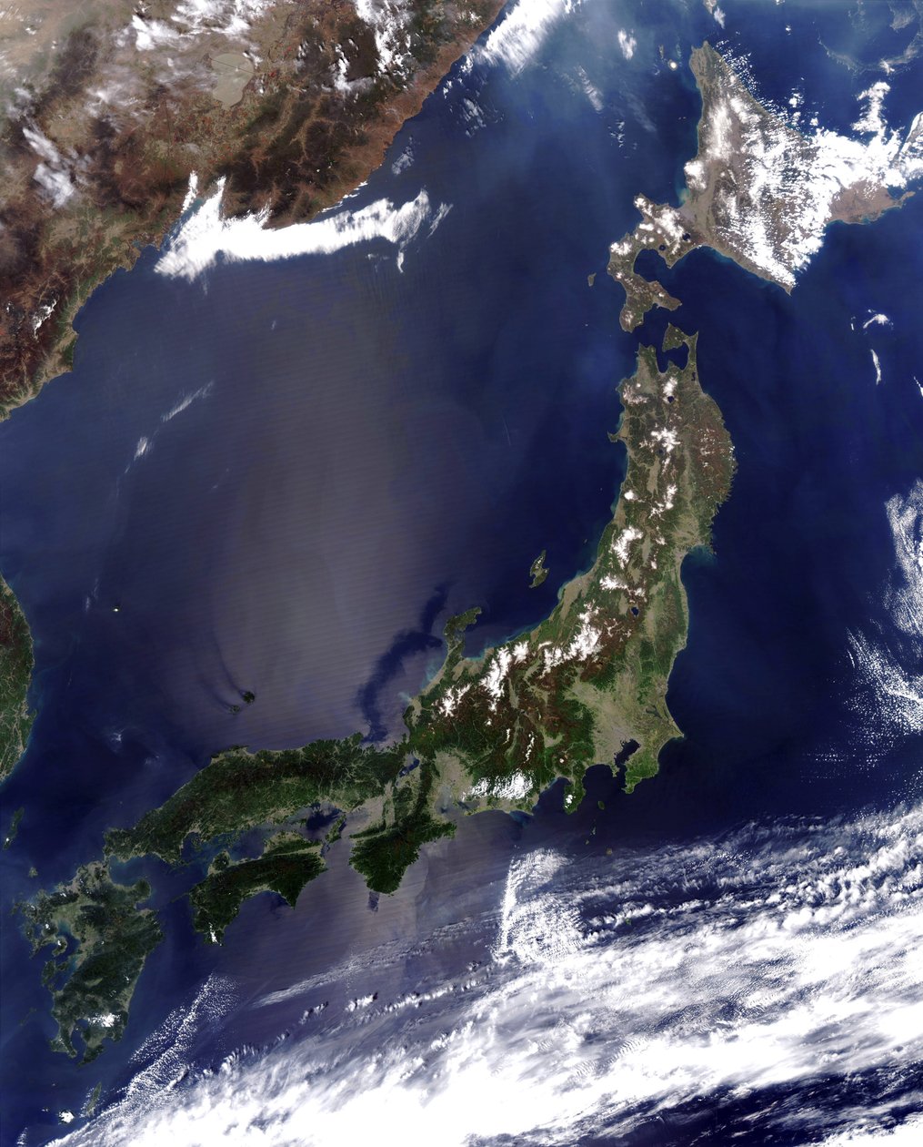
Satellite view of the islands of Japan by National Aeronautics and Space Administration National Aeronautics and Space Administration

Satellite view of the islands of Japan

(Satellite view of the islands of Japan. Credit: NASA. Science Earth Geology Oceanography)


National Aeronautics and Space Administration National Aeronautics and Space Administration

€ 0.00
Enthält ??% MwSt.
   Add to cart
   Configure art print
Undated  ·  Picture ID: 602691

Nonclassified artists

Satellite view of the islands of Japan by National Aeronautics and Space Administration National Aeronautics and Space Administration. Available as an art print on canvas, photo paper, watercolor board, uncoated paper or Japanese paper.
satellite · view · islands · japan · credit · nasa · science · earth · geology · oceanography · photograph · astronomy · science · earth · geology · meteorology · weather
Other color variations of this picture  
zu Favoriten hinzufügen   Add to favorites    Select wall color    View painting in a room AR/3D   View in 3D / AR
0 Reviews

Configure art print

Picture Frame

Medium & Stretcher

Glass & Passepartout

Miscellaneous & Extras

 Save / compare configuration
Preview Icon

Summary

Gemälde
Veredelung
Keilrahmen
Museumslizenz

€ ???.??
(inkl. 20% MwSt)
   Add to cart

Produktionszeit: 2-4 Werktage
Bildschärfe: PERFEKT

Should you desire adjustments to brightness and color, or a custom crop of the motif, we are happy to make these changes at no additional cost to you. Please do not hesitate to contact us.

Similar artworks selected for you

Satellite view of Honshu, Japan, 4 May 2005 with thick plume of smoke crossing the island from the west where intense fires had been burning in North Korea True-color satellite image of Indonesia mid-May 2002. As burning season was not fully underway in the region, skies over the island of Borneo, Malaysia at its northwest coast, are comparatively clear Yucatan peninsula, south-eastern Mexico The Irish Sea full of phytoplankton in this true-color image from January 2002. The Irish Sea separates Ireland from the United Kingdom. This milky appearance is likely due to phytoplankton blooms Korea and the Sea of Japan obscured by swirls of pollution Baja California Seen from Aboard the Second Space Shuttle Flight, November 1981 Satellite view of the Aegean Sea: Crete is island at centre bottom In this satellite image, bloom of the toxic alga Karenia brevis is visible along the west coast of Florida Asia, True Colour Satellite Image Satellite view over Indian peninsula. Sri Lanka is just visible under cloud at bottom right Asia with Country Borders and Cloud Coverage, True Colour Satellite Image Asia with Cloud Coverage, True Colour Satellite Image Satellite photograph of the Tasman Sea partially covered by cloud Satellite view of the Gulf Coast, USA - Tamaulipas, Mexico, to New Orleans, Louisiana Earth from Space - Eleuthera Island, Bahamas The cold, productive waters of the Greenland Sea and Norwegian Sea are revealed in this SeaWiFS image True-color satellite image of the River Amazon, down which flows one fifth of river water entering Earth Satellite image of the Pacific Ocean near Japan with a large brown cloud, possibly caused by the eruption of Mount Oyama on Miyakejima island, Japan Oceania with Cloud Coverage, True Colour Satellite Image Asia at Night with Country Borders and Cloud Coverage, True Colour Satellite Image Oceania at Night, True Colour Satellite Image Earth from Space - Europe Seen from a Satellite, 1980s National Snow and Ice Data Centre observations of the Arctic Sea ice coverage in 2008, the second-lowest amount recorded Satellite image of Iceland on 28 January 2004 showing it covered in a blanket of snow and ice which is obscuring the permanent glaciers and icecaps that exist year-round Large areas of parts of Bangladesh (left of center) and India (left edge and upper right) are under water, 3 August 2003. Bright blue is rivers, lakes and flooded areas. Dark area left foreground is Bay of Bengal Asia at Night, True Colour Satellite Image Satellite image, 5 October 2002, showing water-logged lowlands in India and Bangladesh. Bright blue is rivers, lakes and flooded areas. Dark area center foreground is Bay of Bengal Four Corners region of southwest United States. Forest-covered Rocky Mountains, which still have snow-covered peaks, running through Colorado and into New Mexico
Show more similar artworks

Other art prints by National Aeronautics and Space Administration National Aeronautics and Space Administration

Eleuthera Island, Bahamas Satellite view of the Pyramids of Giza, Egypt The Helix Nebula (NGC 7293), sometimes called The Eye of God, a large planetary nebula in the constellation Aquarius True-color satellite image of the River Amazon, down which flows one fifth of river water entering Earth Satellite view of the Aegean Sea: Crete is island at centre bottom Satellite view of North, Central and South America, set between the Pacific and Atlantic oceans Earthrise Seen from Surface of Moon: Apollo Mission 1969 Image of the surface of Saturn Satellite view of the Earth with North America in the center of the image Satellite view of Japan with snow-covered mountains, Spring greening land at lower levels. Dust from mainland China blowing over the Sea of Japan, and out into the Pacific Ocean Satellite view of the islands of Japan Image of Uranus obtained by the Hubble Telescope Victoria Crater, impact crater at Meridiani Planum, near equator of Mars, approximately 800 meters in diameter Satellite view of the Pyramids of Giza, Egypt Spiral Galaxy M81 viewed from the Hubble Space Telescope
Show More Artworks

Excerpt from our top sellers

Blue Cave Reclining Female Nude with Spread Legs Two Girls Moon rising Over the Sea The Oceanids Mending the Sail, 1896 Christ in the House of His Parents, 1863 Lady with Peacock Fan Still Life with Cherries and Peaches Lamia The Stages of Life Arm of the Seine near Vétheuil The Interior of the Palm House Breakfast Time Napoleon I Bonaparte studying at the Royal Military School of Brienne. Its shadow falls on the geographic map of Europe. Illustration by Jacques Marie Gaston Onfray de Breville dit JOB
Show More Artworks


What our customers think about us


Frequently Asked Questions about Meisterdrucke


Personalizing your art print at Meisterdrucke is a simple and intuitive process that allows you to design an artwork exactly to your specifications: Choose a frame, determine the image size, decide on a printing medium, and add suitable glazing or a stretcher frame. We also offer customization options such as mats, fillets, and spacers. Our customer service is available to help you design your perfect artwork.

At Meisterdrucke, you have the fascinating option to visualize the artwork you configured directly in your own space. For a tailored preview, simply upload a photo of your room and let the artwork appear on it. If you visit us via a mobile device, be it a phone or tablet, our augmented reality feature brings the image to life and seamlessly projects it into your space. An experience that uniquely combines art and technology.

Choosing the medium is often a matter of personal taste. To give you a clearer idea, we have provided some images for each medium. For a holistic experience, we also offer you a sample set of all paper variants so you can make a decision not just visually but also haptically. You can take advantage of the sample set free of charge – only the shipping costs will apply. You can order the sample set directly.

Do not worry. At Meisterdrucke, we do not proceed mechanically. We manually review each order. If there are any inconsistencies or peculiarities in the configuration, we will immediately contact you. Of course, our courteous and patient support is always at your side to assist you with the configuration. Together with you, we adjust your image by phone or email so that the final result exactly meets your expectations.


Do you have any questions?

Are you interested in an art print from our manufactory but still unsure? Do you need advice on choosing the medium or help with the order?

Our experts are happy to assist you.

+43 4257 29415
support@meisterdrucke.com
Mo-Do: 7:00 - 16:00 | Fr: 7:00 - 13:00

Do you have any questions?

Are you interested in an art print from our manufactory but still unsure? Do you need advice on choosing the medium or help with the order?

Our experts are happy to assist you.

+43 4257 29415
support@meisterdrucke.com
Mo-Do: 7:00 - 16:00 | Fr: 7:00 - 13:00


Meisterdrucke

   Kärntner Strasse 46
        9586 Finkenstein am Faaker See
        Austria
        +43 4257 29415
        support@meisterdrucke.com
Other languages

                   
Erfahrungen & Bewertungen zu Meisterdrucke
Partner Logos

Kaiser Franz Joseph

Meisterdrucke
Kärntner Strasse 46
9586 Finkenstein am Faaker See · Austria
+43 4257 29415 · office@meisterdrucke.com
Partner Logos


(c) 2023 meisterdrucke.us