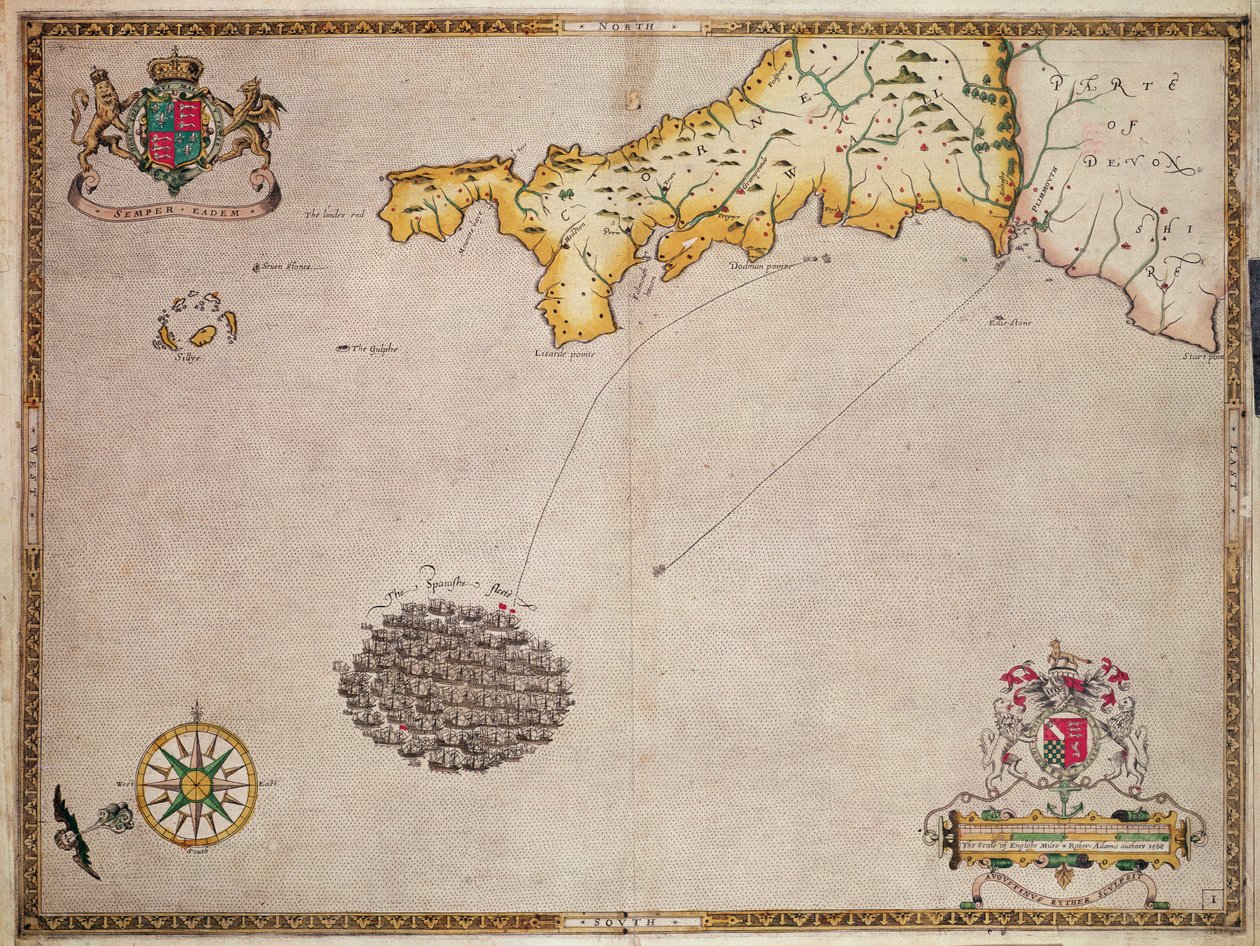
Map No. 1 Showing the Route of the Armada Fleet, Engraved by Augustine Ryther by Robert Adams

Map No. 1 Showing the Route of the Armada Fleet, Engraved by Augustine Ryther

(Map No. 1 showing the route of the Armada fleet, engraved by Augustine Ryther, 1588 )


Robert Adams

€ 0.00
Enthält ??% MwSt.
   Add to cart
   Configure art print
1588  ·  Gravur  ·  Picture ID: 103980

Nonclassified artists  ·  Cartography

Map No. 1 Showing the Route of the Armada Fleet, Engraved by Augustine Ryther by Robert Adams. Available as an art print on canvas, photo paper, watercolor board, uncoated paper or Japanese paper.
spanish · ship · english channel · scale · coat of arms · county · scale · battle · elizabethan · coastline · strategy · plan · navy · army · naval · Private Collection / Bridgeman Images
zu Favoriten hinzufügen   Add to favorites    Select wall color    View painting in a room AR/3D   View in 3D / AR
0 Reviews

Configure art print

Picture Frame

Medium & Stretcher

Glass & Passepartout

Miscellaneous & Extras

 Save / compare configuration
Preview Icon

Summary

Gemälde
Veredelung
Keilrahmen
Museumslizenz

€ 115.42
(inkl. 20% MwSt)
   Add to cart

Bildschärfe: PERFEKT

Should you desire adjustments to brightness and color, or a custom crop of the motif, we are happy to make these changes at no additional cost to you. Please do not hesitate to contact us.

Similar artworks selected for you

The Spanish and English fleets near Plymouth on 30 - 31 July The English Pursue the Spanish Fleet East of Plymouth on 31 July - 1 August The Battle off the Isle of Wight on 4 August The English engage the Spanish fleet near Plymouth on 31 July The battle off the Isle of Wight on 4 August Sicily (towns: Messina, Milazzo, Catania, Trapani, Italy) Map of the Kingdom of Sicily, Italy, with views of the cities of Messina, Milazzo, Palermo, Catania and Trapani Map of the County of Cornwall Campania, Italy, in Map of Cornwall, in The Last and Most Accurate Description of Jamaica Map of the Island of Crete, with Views of the Fortified Towns La Cane and Heraklion and the Fortresses of Spinalonga, Retino, Thine and Souda The English and Spanish fleets between Portland Bill and the Isle of Wight on 2 - 3 August 1588 Crete Insulae Melitae vulgo Malta nova et accurata descriptio Carnarvonshire and Anglesey, in Dover to Sandwich and Blacknerse to Gravelines - The Spanish Armada and the English Fleet off Calais, c. 1590 Map of the Kingdom of Naples, Italy, from Theatrum Orbis Terrarum The Battle off Gravelines, 8 August 1588 Glamorganshire, in Map of The Confines of Siena Republic of Genoa, Map by Jan Baptist Vrients, Copper engraving Map of Duchy of Monferrato, Engraving from Regionum Italiae Map of Liguria Region Map of Malta and Gozo, c.1650 Nice on the Mediterranean Region centered on Bilbao and extending from S Map of Virginia and Florida
Show more similar artworks

Other art prints by Robert Adams

Map No.5 Showing the route of the Armada fleet, engraved by Augustine Ryther Map showing the route of the Armada fleet, engraved by Augustine Ryther, 1588 Map showing the route of the Armada fleet, engraved by Augustine Ryther Map Showing the route of the Armada fleet, engraved by Augustine Ryther Map No. 1 Showing the Route of the Armada Fleet, Engraved by Augustine Ryther Map No.9 showing the route of the Armada fleet, engraved by Augustine Ryther, 1588 Map No.4 Showing the Route of the Armada Fleet, Engraved by Augustine Ryther Map No.8 Showing the Route of the Armada Fleet, Engraved by Augustine Ryther, 1588 Map No.7 Showing the Route of the Armada Fleet, Engraved by Augustine Ryther, 1588 Map No.6 showing the route of the Armada fleet, engraved by Augustine Ryther, 1588 Map No.2 Showing the route of the Armada fleet, engraved by Augustine Ryther, 1588 Map No.10 showing the route of the Armada fleet, engraved by Augustine Ryther
Discover more works by Robert Adams

Other motives from the category Cartography

Detail of the Ile de la Cité, from the Map of Paris c. 1540, known as the Plan de la Tapisserie, made as a Tapestry c. 1570 Map of the Southern Hemisphere, from Map Showing the Extent of Work During the Haussmann Period of Development in Paris from 1854-71, 1871 Map of Paris depicting the city Miniature Nautical Map of the Adriatic, 1624 Map of Surrey, engraved by Jodocus Hondius from John Speed Map of Spain and Portugal Typus Orbis Terrarum, map of the world, from Ortelius Map of Armenia, Colchis, Iberia and Albania, from Map of the County of Middlesex, published 1819 Map of the United States, 1816 Map of the Caribbean and Venezuela, from the Map of Animals in Africa Map of New Belgium with a View of New Amsterdam, compiled by Nicolaes Visscher c.1651-55 Map of the Northern Sky with Representations of the Constellations
View More from "Cartography"

Excerpt from our top sellers

Comrades The young Napoleon Bonaparte studying The Harvesters Portrait of a Young Woman View on Delft La Primavera Ghost of a Genius Geography of Plants in Tropical Countries, A Study of the Andes, drawn by Schoenberger and Turpin, printed by Langlois, Paris Neptune The Swing Bouquet of Sunflowers, 1881 Accent in Rose, 1926 Landscape Scene from Thanatopsis Annunciation (post restoration) World Map Universalis Cosmographia, 1507
Show More Artworks


What our customers think about us


Frequently Asked Questions about Meisterdrucke


Personalizing your art print at Meisterdrucke is a simple and intuitive process that allows you to design an artwork exactly to your specifications: Choose a frame, determine the image size, decide on a printing medium, and add suitable glazing or a stretcher frame. We also offer customization options such as mats, fillets, and spacers. Our customer service is available to help you design your perfect artwork.

At Meisterdrucke, you have the fascinating option to visualize the artwork you configured directly in your own space. For a tailored preview, simply upload a photo of your room and let the artwork appear on it. If you visit us via a mobile device, be it a phone or tablet, our augmented reality feature brings the image to life and seamlessly projects it into your space. An experience that uniquely combines art and technology.

Choosing the medium is often a matter of personal taste. To give you a clearer idea, we have provided some images for each medium. For a holistic experience, we also offer you a sample set of all paper variants so you can make a decision not just visually but also haptically. You can take advantage of the sample set free of charge – only the shipping costs will apply. You can order the sample set directly.

Do not worry. At Meisterdrucke, we do not proceed mechanically. We manually review each order. If there are any inconsistencies or peculiarities in the configuration, we will immediately contact you. Of course, our courteous and patient support is always at your side to assist you with the configuration. Together with you, we adjust your image by phone or email so that the final result exactly meets your expectations.


Do you have any questions?

Are you interested in an art print from our manufactory but still unsure? Do you need advice on choosing the medium or help with the order?

Our experts are happy to assist you.

+43 4257 29415
support@meisterdrucke.com
Mo-Do: 7:00 - 16:00 | Fr: 7:00 - 13:00

Do you have any questions?

Are you interested in an art print from our manufactory but still unsure? Do you need advice on choosing the medium or help with the order?

Our experts are happy to assist you.

+43 4257 29415
support@meisterdrucke.com
Mo-Do: 7:00 - 16:00 | Fr: 7:00 - 13:00


Meisterdrucke

   Kärntner Strasse 46
        9586 Finkenstein am Faaker See
        Austria
        +43 4257 29415
        support@meisterdrucke.com
Other languages

                   
Erfahrungen & Bewertungen zu Meisterdrucke
Partner Logos

Kaiser Franz Joseph

Meisterdrucke
Kärntner Strasse 46
9586 Finkenstein am Faaker See · Austria
+43 4257 29415 · office@meisterdrucke.com
Partner Logos


(c) 2025 meisterdrucke.us