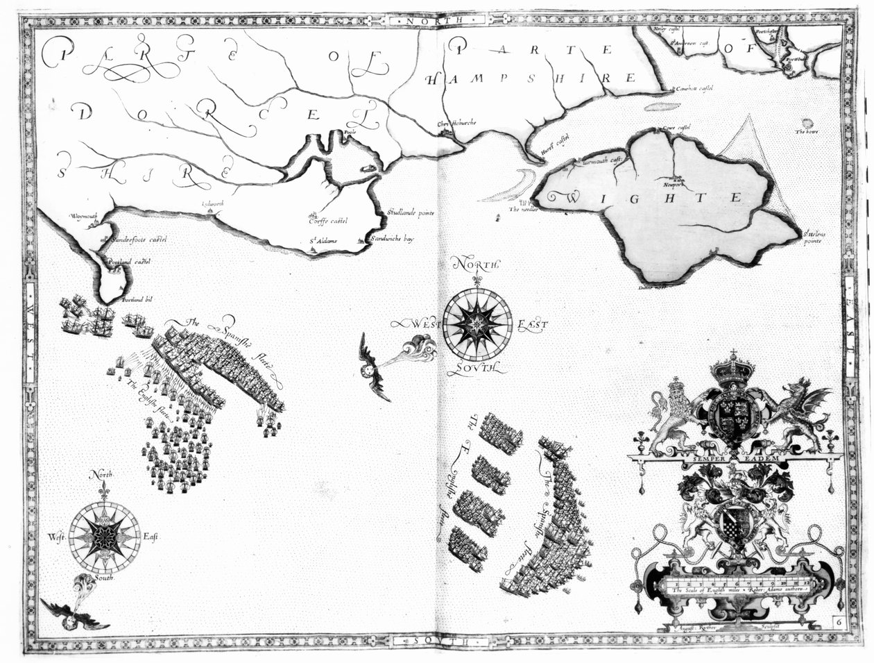
Map No.6 showing the route of the Armada fleet, engraved by Augustine Ryther, 1588 by Robert Adams

Map No.6 showing the route of the Armada fleet, engraved by Augustine Ryther, 1588

(Map No.6 showing the route of the Armada fleet, engraved by Augustine Ryther, 1588 )


Robert Adams

€ 116.48
Enthält 0% MwSt.
   Configure art print
1588  ·  Gravur  ·  Picture ID: 78204

Nonclassified artists  ·  Cartography

Map No.6 showing the route of the Armada fleet, engraved by Augustine Ryther, 1588 by Robert Adams. Available as an art print on canvas, photo paper, watercolor board, uncoated paper or Japanese paper.
spanish fleet · sea battle · naval · ship · english channel · coat of arms · pursuing · chasing · escaping · Private Collection / Bridgeman Images
Other color variations of this picture  
zu Favoriten hinzufügen   Add to favorites    Select wall color    View painting in a room AR/3D   View in 3D / AR
0 Reviews

Configure art print

Picture Frame

Medium & Stretcher

Glass & Passepartout

Miscellaneous & Extras

 Save / compare configuration
Preview Icon

Summary

Gemälde
Veredelung
Keilrahmen
Museumslizenz

€ 116.48
(inkl. 20% MwSt)
   Add to cart

Bildschärfe: PERFEKT

Should you desire adjustments to brightness and color, or a custom crop of the motif, we are happy to make these changes at no additional cost to you. Please do not hesitate to contact us.

Similar artworks selected for you

Map No.9 showing the route of the Armada fleet, engraved by Augustine Ryther, 1588 Map No.2 Showing the route of the Armada fleet, engraved by Augustine Ryther, 1588 Map No.7 Showing the Route of the Armada Fleet, Engraved by Augustine Ryther, 1588 Map No.4 Showing the Route of the Armada Fleet, Engraved by Augustine Ryther A New and Accurate Plan of the City and Harbour of Cartagena, Showing the Descent of That Place by the British Fleet and Land Forces, Under the Command of the Admirals Vernon and Ogle and General Wentworth in March & April 1741 Plan and map of the town, citadel and surroundings of Mont-Louis Map No.8 Showing the Route of the Armada Fleet, Engraved by Augustine Ryther, 1588 Island Elba with Piombino, Italy Map including Massachusetts Bay The Harbour of Cape Cod, from Voyages de Sieur Champlain by Samuel de Champlain, Published in Paris, 1613 The Capture of Cádiz in 1596 Portland Bill to Portsmouth: The Pursuit of the Spanish Armada by the English Fleet Map of Palestine, from a Passover Haggadah, printed in 1695 The capture of the Prussian fortress of Kolberg on 16 December 1761 The English and Spanish fleets between Portland Bill and the Isle of Wight on 2 - 3 August 1588 Map of the Naval Battle between the Swedish and Danish Fleets in the Belt, 1644 (Freti Danici Orsundt Accuratissima Delineatio cum Regis Sueciae, Daniae et Hollandia classibg. Ao. 1644) Map of Lake Ontario with the English and French fleets Plan of Rhodes (Rodos) - in The English and Dutch Force Facing the Spanish Fleet in the Port of Cadiz in 1596 Plan of the Town and Harbour of Cartagena, Colombia Plan of the Bay and City of Rio de Janeiro and the disposition of the French and Portuguese naval forces during the French attack under Duguay-Trouin in 1711, c.1730 Map of the Tribe of Asher, 1590 Map of Laputa, Balnibari, Luggnagg, Glubbdubdrib and Japan, illustration from the first edition of A Correct Plan of the environs of Quebec and of the battle fought on 13th September, 1759 Map of Normandy after an illustration from Theatrum Orbis Terrarum sive Atlas Novus by Willem and Joan Blaeu, plate representing Normandia Ducatus Maps of Holy Island and Farne Island, Northumberland
Show more similar artworks

Other art prints by Robert Adams

Map No.5 Showing the route of the Armada fleet, engraved by Augustine Ryther Map showing the route of the Armada fleet, engraved by Augustine Ryther Map showing the route of the Armada fleet, engraved by Augustine Ryther, 1588 Map Showing the route of the Armada fleet, engraved by Augustine Ryther Map No. 1 Showing the Route of the Armada Fleet, Engraved by Augustine Ryther Map No.9 showing the route of the Armada fleet, engraved by Augustine Ryther, 1588 Map No.4 Showing the Route of the Armada Fleet, Engraved by Augustine Ryther Map No.8 Showing the Route of the Armada Fleet, Engraved by Augustine Ryther, 1588 Map No.7 Showing the Route of the Armada Fleet, Engraved by Augustine Ryther, 1588 Map No.6 showing the route of the Armada fleet, engraved by Augustine Ryther, 1588 Map No.2 Showing the route of the Armada fleet, engraved by Augustine Ryther, 1588 Map No.10 showing the route of the Armada fleet, engraved by Augustine Ryther
Discover more works by Robert Adams

Other motives from the category Cartography

Map of Africa showing Treaty Boundaries, 1891 Map of Atlantis, from Map of Warsaw, from Map of Florence, 1584 Map of Florence (detail) Map of France Map of Paris showing Île de la Cité, from L A map of Constantinople Map of Africa, Published in 1700, Paris Map of Cambrai, from Map of the Siege of Mantua, published by William Blackwood and Sons A New and Correct Map of the World, 1770-97 Map of the Northern Sky with Representations of the Constellations World map of the different time zones, published by Blondel La Rougery in Paris c.1920 Hull, detail from the map of the North and East Ridings of Yorkshire, engraved by Jodocus Hondius from John Speed
View More from "Cartography"

Excerpt from our top sellers

Mont Sainte-Victoire The Dragon among Clouds Starry Night Over the Rhône Sunset Over the Lake Beautiful Princess Castle and Sun The Quiet River, 1913 Winter Landscape with Skaters Horse Study The Artist The Great Wave off the Coast of Kanagawa, c1829-c1831 Boreas, 1903 The Entrance to the Grand Canal, Venice The Annunciation, 1474-75 Noon
Show More Artworks


What our customers think about us


Frequently Asked Questions about Meisterdrucke


Personalizing your art print at Meisterdrucke is a simple and intuitive process that allows you to design an artwork exactly to your specifications: Choose a frame, determine the image size, decide on a printing medium, and add suitable glazing or a stretcher frame. We also offer customization options such as mats, fillets, and spacers. Our customer service is available to help you design your perfect artwork.

At Meisterdrucke, you have the fascinating option to visualize the artwork you configured directly in your own space. For a tailored preview, simply upload a photo of your room and let the artwork appear on it. If you visit us via a mobile device, be it a phone or tablet, our augmented reality feature brings the image to life and seamlessly projects it into your space. An experience that uniquely combines art and technology.

Choosing the medium is often a matter of personal taste. To give you a clearer idea, we have provided some images for each medium. For a holistic experience, we also offer you a sample set of all paper variants so you can make a decision not just visually but also haptically. You can take advantage of the sample set free of charge – only the shipping costs will apply. You can order the sample set directly.

Do not worry. At Meisterdrucke, we do not proceed mechanically. We manually review each order. If there are any inconsistencies or peculiarities in the configuration, we will immediately contact you. Of course, our courteous and patient support is always at your side to assist you with the configuration. Together with you, we adjust your image by phone or email so that the final result exactly meets your expectations.


Do you have any questions?

Are you interested in an art print from our manufactory but still unsure? Do you need advice on choosing the medium or help with the order?

Our experts are happy to assist you.

+43 4257 29415
support@meisterdrucke.com
Mo-Do: 7:00 - 16:00 | Fr: 7:00 - 13:00

Do you have any questions?

Are you interested in an art print from our manufactory but still unsure? Do you need advice on choosing the medium or help with the order?

Our experts are happy to assist you.

+43 4257 29415
support@meisterdrucke.com
Mo-Do: 7:00 - 16:00 | Fr: 7:00 - 13:00


Meisterdrucke

   Kärntner Strasse 46
        9586 Finkenstein am Faaker See
        Austria
        +43 4257 29415
        support@meisterdrucke.com
Other languages

                   
Erfahrungen & Bewertungen zu Meisterdrucke
Partner Logos

Kaiser Franz Joseph

Meisterdrucke
Kärntner Strasse 46
9586 Finkenstein am Faaker See · Austria
+43 4257 29415 · office@meisterdrucke.com
Partner Logos


(c) 2025 meisterdrucke.us