Search by artist, work title or style – e.g. Monet, Starry Night, Impressionism, Hokusai wave, nude. Describe the scene – e.g. green meadow, abstract with lots of red, dark oil painting, standing nude next to a tree.

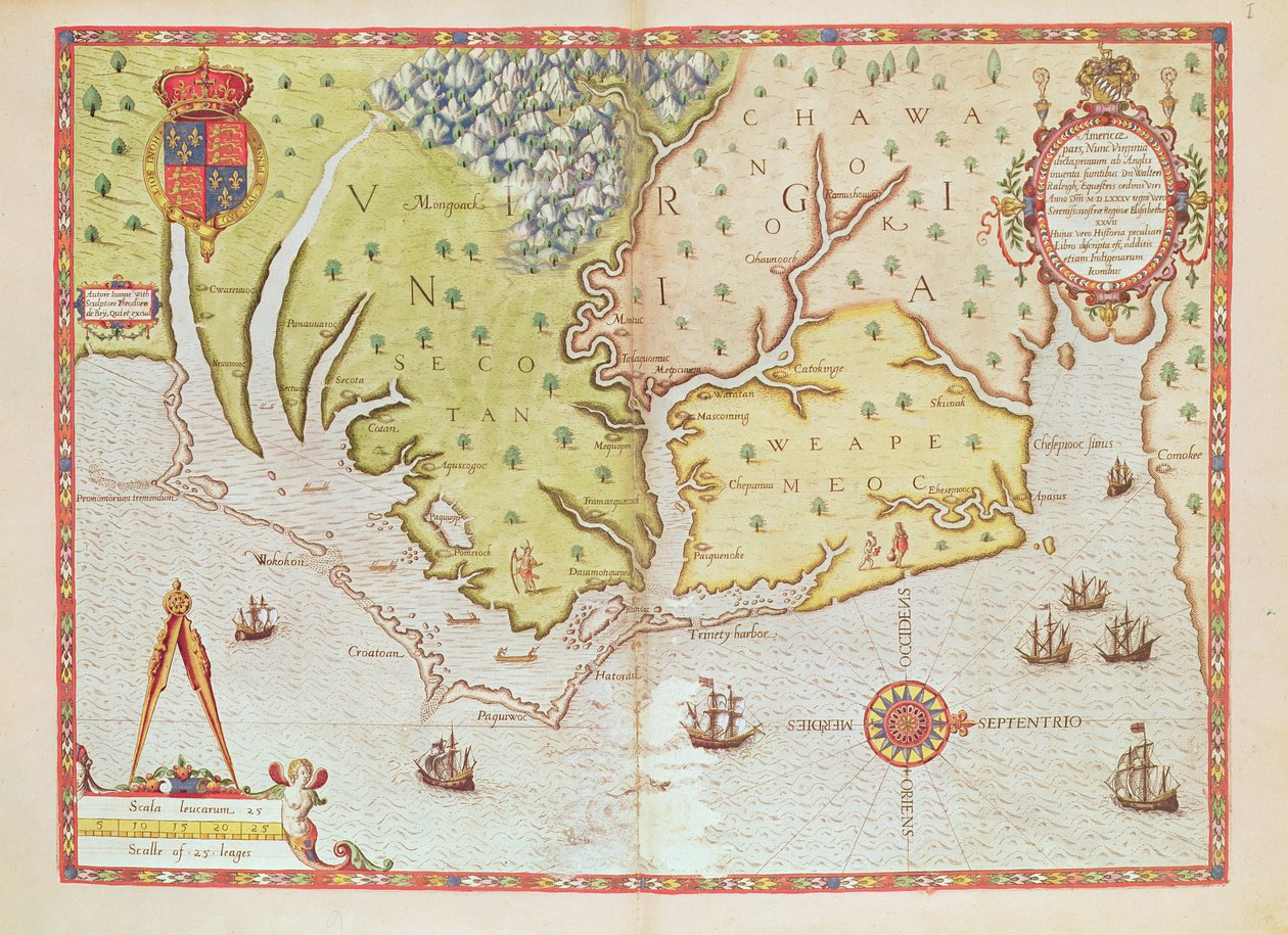
Admiranta Narratio... Map of Virginia, 1585-1588 by Theodore de Bry

Admiranta Narratio... Map of Virginia, 1585-1588

(Admiranta Narratio... Map of Virginia (page 44-45), 1585-1588 (colour engraving_)


Theodore de Bry

€ 123.6
Enthält 0% MwSt.
   Configure art print
1585  ·  colour engraving  ·  Picture ID: 136767

Nonclassified artists  ·  Cartography

Admiranta Narratio... Map of Virginia, 1585-1588 by Theodore de Bry. Available as an art print on canvas, photo paper, watercolor board, uncoated paper or Japanese paper.
print · engraving · flemish artist · virginia · new world · north america · discovering · documenting · geographic · land · admiranta narratio · page 44 · page 45 · colonisation · 16th century · Service Historique de la Marine, Vincennes, France / Bridgeman Images
Other color variations of this picture  
AR/3D   View in 3D / AR zu Favoriten hinzufügen   Add to favorites    Select wall color    View painting in a room
0 Reviews

Configure art print

Picture Frame

Medium & Stretcher

Glass & Passepartout

Miscellaneous & Extras

 Save / compare configuration
Preview Icon

Summary

Gemälde
Veredelung
Keilrahmen
Museumslizenz

€ 123.6
(inkl. 20% MwSt)
   Add to cart

Bildschärfe: PERFEKT

Should you desire adjustments to brightness and color, or a custom crop of the motif, we are happy to make these changes at no additional cost to you. Please do not hesitate to contact us.

Similar artworks selected for you

Oversize Atlas Titled Map of Netherlands, from Theatrum Orbis Terrarum by Abraham Ortelius Newly Discovered Virginia, 1590 Map of 1590 engraved by Theodore de Bry after watercolour by the English colonist John White, governor of Roanoke. Virginia and coast with small islands and Roanoke at mouth of river. Secotan and Weapemeoc native lands The Sea Coasts Between Dover & Orfordness: Including the Most Famous River of Thames with All the Sands, Banks, Flats, & Shoals Thereabouts According to Their True Situation and Appearance The famous West Indian voyage made by the English Fleet of 23 ships and barks wherein were gotten the towns of St. Iago, Sto Domingo, Cartagena and St. Augustines Theatrum Orbis Terrarum Map of Livonia Die custe va Lijfflandt met de eijlanden daer beneffens Extreme northeast coastline of the States, in Map of Livonia The first western atlas map of China, from the Ortelius Theatrum atlas, 1584 Virginia and Florida (engraving) Southeast, in Map of Virginia, showing in upper left hand a picture of Chief Powhatan by John Smith, 1624 Dutch Trade Map of the Baltic Sea Chart of the English Channel DeBry Map of Caribbean & Florida 1594 The English engage the Spanish fleet near Plymouth on 31 July Map of the English Coast between the Isle of Wight and Dover North Carolina, titled Powhatan Description of the Sea Coasts of Eyder Ditmers and Part of Jeverland Illustration from the Map, illustration from the From East Africa to the Tip of Ceylon Province: Friesland, North Holland, South Holland, North Brabant, Limburg, Utrecht, Gelderland, Flevoland, Netherlands A map of Africa, south of the equator, with part of the Indian Ocean, from Theatrum Orbis Terrarum
Show more similar artworks

Other art prints by Theodore de Bry

Sir Walter Raleigh: The Discovery of the Large, Rich and Beautiful Empire of Guiana, from Admiranta Narratio.... Frontispiece (page 1) Nicolaus Copernicus, Renaissance-Era Polymath Interior of William Barents History of America: the explorer Christopher Columbus is welcomed by the Indians on his arrival in the New World (Engraving by Theodore De Bry) History of America: Spaniards exploit gold mines. The Indians work before the eyes of the settlers. Engraving by Theodore de Bry (1528-1598). 16th century Private collection History of America: Tortures inflicted by the Indians on Spanish settlers Scene of Cannibalism in Brazil. Indians devoured their enemies and prisoners. Engraving from Description of Crimes Inflicted on Indians by Spanish Settlers - Spaniards Torturing Indians - Engraving by Theodore de Bry in Christopher Columbus, Genoese explorer, discovering America, 12 May 1492 Description of Crimes Inflicted on Indians by Spanish Settlers - Scene of Torture of Indians by Spanish Conquistadors. Torture on a Grill, Amputation of Hands - Engraving by Theodore de Bry Scene of Cannibalism, from Scene of Cannibalism in Brazil in 1644 Gold mine in Potosi, Bolivia History of America: harvesting sugar cane and sugar production by Indian slaves who work for the Spanish conquistadors (Engraving)
Discover more works by Theodore de Bry

Other motives from the category Cartography

Map of the Valley of Mexico at the Time of the Conquest, from History of The Conquest of Mexico, published 1850 Map of Hamburg Showing its First Opera House, 1690 Double Hemisphere World Map, 1587 Map of Great Britain, France and Spain Map of the Moluccas, 1522 Map of Cadiz, from Map of London in the 11th Century The Countye Palatine of Chester, engraved by Jodocus Hondius (1563-1612) from John Speed A map of Spain and Portugal, c.1869 A New and Correct Map of the Trading Part of the West Indies Map of the parts of Europe and Asia adjacent to Constantinople, from Map of New France Dedicated to Colbert by Duchesneau, Intendant (detail) Map of Paris at the Outbreak of the French Revolution, published by William Blackwood and Sons Map of the Region of Chinon Related to the Works of Francois Rabelais Map of Trento, from
View More from "Cartography"

Excerpt from our top sellers

Lying Dog in the Snow Farmhouse in Provence Blue Fox The Bookworm The Isle of the Dead, Fifth Version, 1886 Cosmic Cliffs in the Carina Nebula Fishermen at Sea Pandemonium The Great Wave off the Coast of Kanagawa, c1829-c1831 Irises Chalk Paths Boys Bathing The Youth of Bacchus Portrait of Joan of Arc with flag and lilies on the background of Notre Dame Cathedral The Mountain Mowers, First Version
Show More Artworks


What our customers think about us


Frequently Asked Questions about Meisterdrucke


Personalizing your art print at Meisterdrucke is a simple and intuitive process that allows you to design an artwork exactly to your specifications: Choose a frame, determine the image size, decide on a printing medium, and add suitable glazing or a stretcher frame. We also offer customization options such as mats, fillets, and spacers. Our customer service is available to help you design your perfect artwork.

At Meisterdrucke, you have the fascinating option to visualize the artwork you configured directly in your own space. For a tailored preview, simply upload a photo of your room and let the artwork appear on it. If you visit us via a mobile device, be it a phone or tablet, our augmented reality feature brings the image to life and seamlessly projects it into your space. An experience that uniquely combines art and technology.

Choosing the medium is often a matter of personal taste. To give you a clearer idea, we have provided some images for each medium. For a holistic experience, we also offer you a sample set of all paper variants so you can make a decision not just visually but also haptically. You can take advantage of the sample set free of charge – only the shipping costs will apply. You can order the sample set directly.

Do not worry. At Meisterdrucke, we do not proceed mechanically. We manually review each order. If there are any inconsistencies or peculiarities in the configuration, we will immediately contact you. Of course, our courteous and patient support is always at your side to assist you with the configuration. Together with you, we adjust your image by phone or email so that the final result exactly meets your expectations.


Do you have any questions?

Are you interested in an art print from our manufactory but still unsure? Do you need advice on choosing the medium or help with the order?

Our experts are happy to assist you.

+43 4257 29415
support@meisterdrucke.com
Mo-Do: 7:00 - 16:00 | Fr: 7:00 - 13:00

Do you have any questions?

Are you interested in an art print from our manufactory but still unsure? Do you need advice on choosing the medium or help with the order?

Our experts are happy to assist you.

+43 4257 29415
support@meisterdrucke.com
Mo-Do: 7:00 - 16:00 | Fr: 7:00 - 13:00


Meisterdrucke

   Kärntner Strasse 46
        9586 Finkenstein am Faaker See
        Austria
        +43 4257 29415
        support@meisterdrucke.com
Other languages

                   
Erfahrungen & Bewertungen zu Meisterdrucke
Post.at DHL Express Quehenberger Cargoboard
Kaiser Franz Joseph

Meisterdrucke
Kärntner Strasse 46
9586 Finkenstein am Faaker See · Austria
+43 4257 29415 · office@meisterdrucke.com
Post.at DHL Express Quehenberger Cargoboard


Meisterdrucke 2752 Bewertungen auf ProvenExpert.com

(c) 2025 meisterdrucke.us